1900s (20th Century) Maps of Sunnyslope, Washington
Explore 7 historic maps of Sunnyslope from the 1900s (20th Century). These maps offer a rare glimpse into what life looked like during the 1900s — showing old roads, neighborhoods, homes, and landmarks that have changed or disappeared over time.
Whether you're researching your family's past, planning a metal detecting trip, or studying how Sunnyslope's landscape evolved across the 1900s, these high-resolution maps are a powerful tool for exploring the history of this region.
- Focus on a specific era: All maps on this page are from the 1900s, giving you a focused view of this time period.
- See what’s changed: Compare century-old streets, trails, and buildings to today's modern landscape using overlays and satellite layers.
- Research with precision: Use these maps for genealogy, historical research, land use analysis, or educational projects.
- View, download, or print: Maps are fully viewable online in high resolution, and can be downloaded or printed for your own records.
Start exploring Sunnyslope's history through authentic maps from the 1900s. This is your window into the past.
Sunnyslope, WA maps
(7)- 1913 Map of Wenatchee, 1964 Print
 1913 Wenatchee1964 Print · USGSThe Wenatchee River valley and Columbia River shoreline thrived in the early 1910s as a burgeoning agricultural and rail hub. Genealogists can trace early homesteads and landmarks like Martins Ranch, the Great Northern Railway, and rural sites like Pitcher School.
 - 1915 Map of Wenatchee
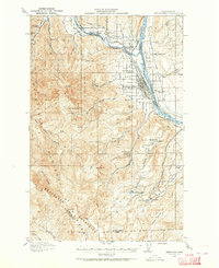
 1915 Wenatchee1915 Print · USGSWenatchee and the Columbia River valley are shown in the years before major dam construction, when the region's orchard economy was firmly established. Researchers can trace early railroad history along the Great Northern or locate rural landmarks like Mortins Ranch and Ferry School.3 unique versions available
 - 1920 Map of Colockum Pass
 1920 Colockum Pass1920 Print · USGSKittitas and Douglas counties are shown during a time of river ferries and mountain ranching. You can trace early schoolhouse locations like Whisky Dick School and follow the old Trinidad Ferry route across the Columbia River.
 - 1922 Map of Colockum Pass
 1922 Colockum Pass1922 Print · USGSEastern Washington ranching and river commerce are captured here just after the Great War, showing a landscape of high mountain passes and vital Columbia River crossings. Genealogists can trace family homesteads like Sheridan Ranch and local rural landmarks including Whisky Dick School and the Trinidad Ferry.2 unique versions available
 - 1957 Map of Wenatchee, 1973 Print
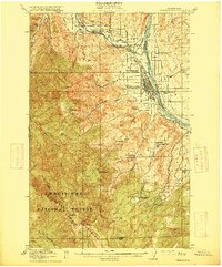
 1957 Wenatchee1973 Print · USGSThe northern Cascades and Columbia River valley appear here in the mid-fifties, showing the region's critical rail and transit corridors. Researchers can trace the routes of the Great Northern RR and Milwaukee Road through settlements like Skykomish, Baring, and Dryden.2 unique versions available
 - 1966 Map of Wenatchee, 1968 Print
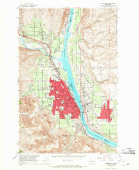 1966 Wenatchee1968 Print · USGSWenatchee and the river valley were flourishing mid-century as major apple-growing and rail hubs. Genealogists and local researchers can locate numerous schools and cemeteries like Sunnyslope Cem, Evergreen Memorial Park, and the Golden King Mine.5 unique versions available
 - 1975 Map of Wenatchee, 1977 Print
 1975 Wenatchee1977 Print · USGSCentral Washington in the mid-seventies shows a landscape of deep mountain valleys and bustling river towns. Trace the industrial and agricultural backbone of the region along the Yakima River and Columbia River, from the mining history of Roslyn to the rail hubs at Cle Elum and Appleyard.
End of results
Showing maps 1-7 of 7
Top cities near Sunnyslope
- Wenatchee historical maps
- East Wenatchee historical maps
- Cashmere historical maps
- Entiat historical maps
- Rock Island historical maps
Frequently asked questions
- What are the different types of historical maps available for Sunnyslope?
- What is the oldest map of Sunnyslope?
- Where can I purchase historical maps of Sunnyslope for my home or office?
- Where can I download high-res historical maps of Sunnyslope?
- Are there historical topographic maps available for Sunnyslope?
- Is there historical aerial imagery available for Sunnyslope?
- Where are historical maps of Sunnyslope sourced from?