1900s (20th Century) Maps of Winton, Washington
Explore 6 historic maps of Winton from the 1900s (20th Century). These maps offer a rare glimpse into what life looked like during the 1900s — showing old roads, neighborhoods, homes, and landmarks that have changed or disappeared over time.
Whether you're researching your family's past, planning a metal detecting trip, or studying how Winton's landscape evolved across the 1900s, these high-resolution maps are a powerful tool for exploring the history of this region.
- Focus on a specific era: All maps on this page are from the 1900s, giving you a focused view of this time period.
- See what’s changed: Compare century-old streets, trails, and buildings to today's modern landscape using overlays and satellite layers.
- Research with precision: Use these maps for genealogy, historical research, land use analysis, or educational projects.
- View, download, or print: Maps are fully viewable online in high resolution, and can be downloaded or printed for your own records.
Start exploring Winton's history through authentic maps from the 1900s. This is your window into the past.
Winton, WA maps
(6)- 1901 Map of Chiwaukum, 1956 Print
 1901 Chiwaukum1956 Print · USGSChelan County is captured at the dawn of the twentieth century as the railroad began to transform the high Cascades. Researchers can trace the original Great Northern R.R. route through mountain hamlets like Merritt, Winton, and the Dardanelles P O.2 unique versions available
 - 1904 Map of Chiwaukum
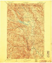 1904 Chiwaukum1904 Print · USGSThe Great Northern corridor and the eastern slopes of the Cascades appear here just after the turn of the century. Trace the rail line through Leavenworth and Merritt, or locate remote landmarks like Soda Spring and Wenatchee Lake.6 unique versions available
 - 1957 Map of Wenatchee, 1973 Print
 1957 Wenatchee1973 Print · USGSThe northern Cascades and Columbia River valley appear here in the mid-fifties, showing the region's critical rail and transit corridors. Researchers can trace the routes of the Great Northern RR and Milwaukee Road through settlements like Skykomish, Baring, and Dryden.2 unique versions available
 - 1964 Map of Leavenworth, 1966 Print
 1964 Leavenworth1966 Print · USGSThe Wenatchee River valley and its rail-and-river network are captured in detail during the mid-sixties. Researchers can trace the development of Leavenworth and Peshastin, or locate family-history sites like the Leavenworth Cem and Medicine Spring.3 unique versions available
 - 1975 Map of Chelan, 1977 Print
 1975 Chelan1977 Print · USGSThe northern Cascades meet the Columbia River in the mid-seventies, showing the deep glacial valleys and high plateaus of central Washington. Trace the legacy of mountain railroading through Tumwater Canyon and explore the lakeshore communities of Manson and Lakeside.2 unique versions available
 - 1989 Map of Winton
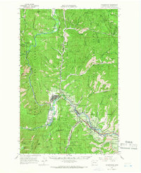
 1989 Winton1989 Print · USGSThe Wenatchee River corridor in the late eighties reveals a landscape of industrial utility and mountain recreation. Trace the railway through the tunnel or locate family-named features like Freund Creek and the small settlement of Winton.
End of results
Showing maps 1-6 of 6
Top cities near Winton
Frequently asked questions
- What are the different types of historical maps available for Winton?
- What is the oldest map of Winton?
- Where can I purchase historical maps of Winton for my home or office?
- Where can I download high-res historical maps of Winton?
- Are there historical topographic maps available for Winton?
- Is there historical aerial imagery available for Winton?
- Where are historical maps of Winton sourced from?