1900s (20th Century) Maps of Elwha, Washington
Explore 5 historic maps of Elwha from the 1900s (20th Century). These maps offer a rare glimpse into what life looked like during the 1900s — showing old roads, neighborhoods, homes, and landmarks that have changed or disappeared over time.
Whether you're researching your family's past, planning a metal detecting trip, or studying how Elwha's landscape evolved across the 1900s, these high-resolution maps are a powerful tool for exploring the history of this region.
- Focus on a specific era: All maps on this page are from the 1900s, giving you a focused view of this time period.
- See what’s changed: Compare century-old streets, trails, and buildings to today's modern landscape using overlays and satellite layers.
- Research with precision: Use these maps for genealogy, historical research, land use analysis, or educational projects.
- View, download, or print: Maps are fully viewable online in high resolution, and can be downloaded or printed for your own records.
Start exploring Elwha's history through authentic maps from the 1900s. This is your window into the past.
Elwha, WA maps
(5)- 1919 Map of Port Crescent
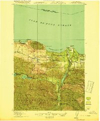 1919 Port Crescent1919 Print · USGSThe northern Olympic Peninsula comes alive in this survey, showing the shoreline from Agate Bay to Freshwater Bay. Trace the early timber economy through the Logging RR and find vanished sites like Port Crescent or the East Beach ferry landing.4 unique versions available
 - 1950 Map of Elwha, 1955 Print
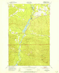 1950 Elwha1955 Print · USGSThe Olympic Peninsula wilderness comes to life in this mid-century survey of the Elwha River corridor. Researchers can trace the original reservoir footprints of Lake Aldwell and find historic sites like Waumilla Lodge and the Dry Creek Sch.5 unique versions available
 - 1950 Map of Joyce, 1960 Print
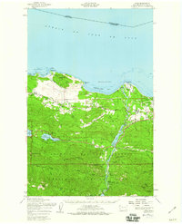 1950 Joyce1960 Print · USGSCoastal Clallam County at mid-century reveals a landscape of working timberlands and emerging mountain parkland. Researchers can trace the Old Piedmont Railroad Grade or locate early settlements like Ramapo, Maple Grove, and Snug Harbor.2 unique versions available
 - 1957 Map of Victoria, 1960 Print
 1957 Victoria1960 Print · USGSThe San Juan Islands and the North Cascades coastline are shown in detail during the late fifties, a period of significant military and industrial presence. Researchers can trace historic rail lines like the Great Northern or locate sites such as the Whidbey Island Naval Air Sta and Friday Harbor.4 unique versions available
 - 1979 Map of Port Angeles
 1979 Port Angeles1979 Print · USGSThe northern Olympic Peninsula and southern Vancouver Island are captured here in the late seventies. Family historians can trace the rail networks of the Esquimalt and Nanaimo Railway or locate old coastal settlements like Sooke, Joyce, and Agnew.
End of results
Showing maps 1-5 of 5
Top cities near Elwha
Frequently asked questions
- What are the different types of historical maps available for Elwha?
- What is the oldest map of Elwha?
- Where can I purchase historical maps of Elwha for my home or office?
- Where can I download high-res historical maps of Elwha?
- Are there historical topographic maps available for Elwha?
- Is there historical aerial imagery available for Elwha?
- Where are historical maps of Elwha sourced from?