1900s (20th Century) Maps of Forks, Washington
Explore 9 historic maps of Forks from the 1900s (20th Century). These maps offer a rare glimpse into what life looked like during the 1900s — showing old roads, neighborhoods, homes, and landmarks that have changed or disappeared over time.
Whether you're researching your family's past, planning a metal detecting trip, or studying how Forks's landscape evolved across the 1900s, these high-resolution maps are a powerful tool for exploring the history of this region.
- Focus on a specific era: All maps on this page are from the 1900s, giving you a focused view of this time period.
- See what’s changed: Compare century-old streets, trails, and buildings to today's modern landscape using overlays and satellite layers.
- Research with precision: Use these maps for genealogy, historical research, land use analysis, or educational projects.
- View, download, or print: Maps are fully viewable online in high resolution, and can be downloaded or printed for your own records.
Start exploring Forks's history through authentic maps from the 1900s. This is your window into the past.
Forks, WA maps
(9)- 1939 Map of Forks
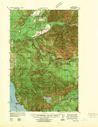 1939 Forks1939 Print · USGSThe Olympic Peninsula logging and oil frontier comes into focus here just before the Second World War. Researchers can trace family homesteads like the Otto Dimmel Ranch alongside industrial landmarks like the Bloedel Donovan Beaver Camp and Oil City Camp.
 - 1943 Map of Copalis Beach
 1943 Copalis Beach1943 Print · USGSThe Washington coast in the 1940s is detailed here from the Olympic Peninsula to the Columbia River. Trace old beach settlements like Moclips and Copalis Beach alongside landmarks like the Willapa Bay Lighthouse.
 - 1951 Map of Copalis Beach
 1951 Copalis Beach1951 Print · USGSThe Olympic Peninsula's rugged coast and tribal lands are meticulously detailed in the early 1950s. Genealogists and historians can trace the foundations of coastal communities from Taholah to La Push or locate early markers like the James Island Lighthouse.
 - 1957 Map of Forks, 1959 Print
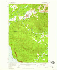 1957 Forks1959 Print · USGSThe Olympic Peninsula comes into focus in the late fifties as timber and early oil exploration shape the landscape. Researchers can trace the Logging Railroad near Forks, locate the Cassel Sch, and find the remote Wilson Ranch.3 unique versions available
 - 1957 Map of Copalis Beach, 1968 Print
 1957 Copalis Beach1968 Print · USGSThe Washington coast during the late fifties reveals a landscape of tribal reservations and timber towns linked by the Northern Pacific RR. Trace family history and land patterns near Forks Cemetery, the shingle mill, or coastal landings like Taholah and Oysterville.2 unique versions available
 - 1963 Map of Copalis Beach
 1963 Copalis Beach1963 Print · USGSThe Washington coast in the early sixties reveals a landscape of massive timber reserves, indigenous lands, and quiet seaside villages. Genealogists and historians can trace the foundations of coastal life through sites like Lone Fir Cemetery, the Dismantled RR, and the historic oyster beds of Oysterville.
 - 1981 Map of Forks, 1982 Print
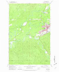 1981 Forks1982 Print · USGSThe convergence of the Soleduck River, Calawah River, and Bogachiel River defines this Olympic Peninsula town in the early eighties. Trace local landmarks like the Community Hosp, Municipal Airport, and the Old RR Grade.
 - 1981 Map of Reade Hill, 1982 Print
 1981 Reade Hill1982 Print · USGSThe Olympic Peninsula logging town of Forks is shown in the early eighties as it expanded into the surrounding timberlands. Genealogists and local historians can trace the early streets of Forks, the local Cem, and the recreation sites at Bogachiel State Park.
 - 1988 Map of Forks
 1988 Forks1988 Print · USGSThe Olympic Peninsula's western coastline and timber heartland are documented here in the late eighties, from the high ridges to the Pacific shelf. Local researchers can trace the coastal settlements of La Push and Mora or locate remote sites like Destruction Island.
End of results
Showing maps 1-9 of 9
Frequently asked questions
- What are the different types of historical maps available for Forks?
- What is the oldest map of Forks?
- Where can I purchase historical maps of Forks for my home or office?
- Where can I download high-res historical maps of Forks?
- Are there historical topographic maps available for Forks?
- Is there historical aerial imagery available for Forks?
- Where are historical maps of Forks sourced from?