1900s (20th Century) Maps of Ovington, Washington
Explore 6 historic maps of Ovington from the 1900s (20th Century). These maps offer a rare glimpse into what life looked like during the 1900s — showing old roads, neighborhoods, homes, and landmarks that have changed or disappeared over time.
Whether you're researching your family's past, planning a metal detecting trip, or studying how Ovington's landscape evolved across the 1900s, these high-resolution maps are a powerful tool for exploring the history of this region.
- Focus on a specific era: All maps on this page are from the 1900s, giving you a focused view of this time period.
- See what’s changed: Compare century-old streets, trails, and buildings to today's modern landscape using overlays and satellite layers.
- Research with precision: Use these maps for genealogy, historical research, land use analysis, or educational projects.
- View, download, or print: Maps are fully viewable online in high resolution, and can be downloaded or printed for your own records.
Start exploring Ovington's history through authentic maps from the 1900s. This is your window into the past.
Ovington, WA maps
(6)- 1918 Map of Lake Crescent, 1958 Print
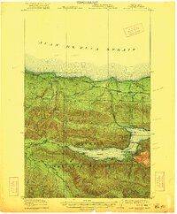
 1918 Lake Crescent1958 Print · USGSThe northern Olympic Peninsula in the early twentieth century was a landscape of deep glacial lakes and heavy timber industry. Genealogists and historians can trace rail-era settlements like Gettysburg and Fairholm, or locate old landmarks like Twin School and the Crescent Lake Tavern.
 - 1922 Map of Lake Crescent
 1922 Lake Crescent1922 Print · USGSCoastal Clallam County at the start of the 1920s shows a rugged landscape of timber railroads and lakeside resorts. Genealogists and historians can locate early landmarks like Twin School, Grubbs Landing, and the Crescent Lake Tavern.3 unique versions available
 - 1950 Map of Lake Crescent, 1955 Print
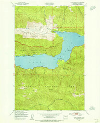 1950 Lake Crescent1955 Print · USGSThe northern Olympic Peninsula comes to life in this mid-century survey, showing the deep waters of Lake Crescent before the full modernization of the regional corridor. Trace the path of the Port Angeles and Western railroad and find lakeside landmarks like Piedmont, Ovington, and the Ranger Station.3 unique versions available
 - 1950 Map of Lake Crescent, 1960 Print
 1950 Lake Crescent1960 Print · USGSClallam County at mid-century reveals a landscape of deep timber and glacial lakes during the height of the Olympic Peninsula's logging era. Trace the path of the Old Railroad Grade and locate old lakeside landings at Fairholm, Piedmont, and Ovington.3 unique versions available
 - 1957 Map of Victoria, 1960 Print
 1957 Victoria1960 Print · USGSThe San Juan Islands and the North Cascades coastline are shown in detail during the late fifties, a period of significant military and industrial presence. Researchers can trace historic rail lines like the Great Northern or locate sites such as the Whidbey Island Naval Air Sta and Friday Harbor.4 unique versions available
 - 1979 Map of Port Angeles
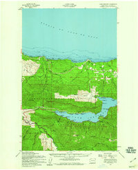
 1979 Port Angeles1979 Print · USGSThe northern Olympic Peninsula and southern Vancouver Island are captured here in the late seventies. Family historians can trace the rail networks of the Esquimalt and Nanaimo Railway or locate old coastal settlements like Sooke, Joyce, and Agnew.
End of results
Showing maps 1-6 of 6
Frequently asked questions
- What are the different types of historical maps available for Ovington?
- What is the oldest map of Ovington?
- Where can I purchase historical maps of Ovington for my home or office?
- Where can I download high-res historical maps of Ovington?
- Are there historical topographic maps available for Ovington?
- Is there historical aerial imagery available for Ovington?
- Where are historical maps of Ovington sourced from?