1950s Maps of Pysht, Washington
Explore 2 historic maps of Pysht from the 1950s. These maps offer a rare glimpse into what life looked like during the 1950s — showing old roads, neighborhoods, homes, and landmarks that have changed or disappeared over time.
Whether you're researching your family's past, planning a metal detecting trip, or studying how Pysht's landscape evolved across the 1950s, these high-resolution maps are a powerful tool for exploring the history of this region.
- Focus on a specific era: All maps on this page are from the 1950s, giving you a focused view of this time period.
- See what’s changed: Compare century-old streets, trails, and buildings to today's modern landscape using overlays and satellite layers.
- Research with precision: Use these maps for genealogy, historical research, land use analysis, or educational projects.
- View, download, or print: Maps are fully viewable online in high resolution, and can be downloaded or printed for your own records.
Start exploring Pysht's history through authentic maps from the 1950s. This is your window into the past.
Pysht, WA maps
(2)- 1953 Map of Cape Flattery, 1968 Print
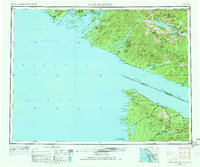 1953 Cape Flattery1968 Print · USGSThe maritime border between Washington and British Columbia comes into sharp focus during the mid-century, detailing the remote coastal reaches of both nations. Researchers can trace the layout of the Makah Indian Res and fishing outposts like Sekiu and Port Renfrew.2 unique versions available
 - 1957 Map of Pysht, 1958 Print
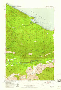 1957 Pysht1958 Print · USGSCoastal Clallam County at mid-century shows a landscape transitioning from its heavy timber-harvesting roots to modern forest management. You can trace the path of an Old Railroad Grade and locate mountain sites like the Kloshe Nanich Lookout and Snider Ranger Sta.3 unique versions available
End of results
Showing maps 1-2 of 2
Top cities near Pysht
Frequently asked questions
- What are the different types of historical maps available for Pysht?
- What is the oldest map of Pysht?
- Where can I purchase historical maps of Pysht for my home or office?
- Where can I download high-res historical maps of Pysht?
- Are there historical topographic maps available for Pysht?
- Is there historical aerial imagery available for Pysht?
- Where are historical maps of Pysht sourced from?