Old Maps of Pysht, Washington for Metal Detecting
Plan your next treasure hunt with 8 historic maps of Pysht. Find old homesites, ghost towns, trails, and gathering spots that may be lost to time — perfect for identifying promising metal detecting locations.
- Locate forgotten sites: Uncover places like long-lost settlements, abandoned rail lines, or gathering spots.
- Plan better hunts: Use map overlays combined with LiDAR or satellite views to narrow in on historically rich areas.
- Made for detectorists: Thousands of hobbyists use these maps to discover relics, coins, and hidden history.
Use these historic maps to boost your research and find new opportunities beneath the surface of Pysht.
Pysht, WA maps
(8)- 1922 Map of Pysht
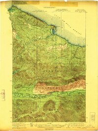 1922 Pysht1922 Print · USGSCoastal timber country on the Olympic Peninsula comes to life in the early twentieth century, showing the interface between the Juan de Fuca Strait and the deep woods. Trace the path of the Logging R. R. and locate remote outposts like Snider Ranger Sta and Pysht.3 unique versions available
 - 1942 Map of Pysht
 1942 Pysht1942 Print · USGSCoastal Clallam County during the early 1940s reveals a landscape defined by industrial timber harvesting and rugged Olympic Peninsula topography. Genealogists and historians can trace the Bloedel Donovan Lumber Mills Logging RR or locate the Indian Cem near the mouth of the Pysht River.
 - 1953 Map of Cape Flattery, 1968 Print
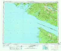 1953 Cape Flattery1968 Print · USGSThe maritime border between Washington and British Columbia comes into sharp focus during the mid-century, detailing the remote coastal reaches of both nations. Researchers can trace the layout of the Makah Indian Res and fishing outposts like Sekiu and Port Renfrew.2 unique versions available
 - 1957 Map of Pysht, 1958 Print
 1957 Pysht1958 Print · USGSCoastal Clallam County at mid-century shows a landscape transitioning from its heavy timber-harvesting roots to modern forest management. You can trace the path of an Old Railroad Grade and locate mountain sites like the Kloshe Nanich Lookout and Snider Ranger Sta.3 unique versions available
 - 1963 Map of Cape Flattery
 1963 Cape Flattery1963 Print · USGSThe Pacific Northwest coast and the entrance to the Puget Sound are captured in detail during the early 1960s. Researchers can trace remote coastal settlements and tribal lands including the Makah Indian Reserve, Port Renfrew, and the timber town of Sekiu.
 - 1984 Map of Pysht
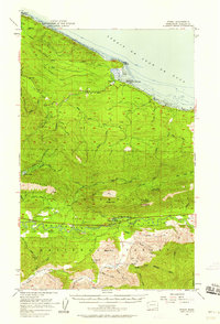
 1984 Pysht1984 Print · USGSThe Clallam County coastline comes into focus in the mid-1980s, centered on the historic timber community of Pysht. Researchers can trace the river forks and coastal landmarks like Pillar Point, Butler Cove, and the Pysht Millpond.
 - 1986 Map of Cape Flattery, 1987 Print
 1986 Cape Flattery1987 Print · USGSThe tip of the Olympic Peninsula and the waters of the Strait of Juan de Fuca are captured here in the mid-eighties. Researchers can trace tribal lands like the Makah Indian Reservation, the remote Old Royal settlement, and maritime landmarks like Cemetery Point.
 - 2023 Map of Pysht, 2023 Print
 2023 Pysht2023 Print · USGSThe Olympic Peninsula coast near Clallam County comes alive in this recent survey of the Strait of Juan de Fuca shoreline. Genealogists and local historians can trace the topography around the settlement of Pysht, the old Pysht Millpond, and landmarks like Pillar Point.
End of results
Showing maps 1-8 of 8
Top cities near Pysht
Frequently asked questions
- What are the different types of historical maps available for Pysht?
- What is the oldest map of Pysht?
- Where can I purchase historical maps of Pysht for my home or office?
- Where can I download high-res historical maps of Pysht?
- Are there historical topographic maps available for Pysht?
- Is there historical aerial imagery available for Pysht?
- Where are historical maps of Pysht sourced from?