Old Maps of Ramapo, Washington for Hiking & Exploration
Hike through history with 10 historic maps of Ramapo. Explore old trails, ghost towns, and forgotten backroads — perfect for outdoor adventurers and local explorers.
- Rediscover forgotten places: Map out old mining camps, roads, and footpaths that no longer exist on modern maps.
- Layer with modern tools: Combine with LiDAR or satellite views to plan hikes through historical terrain.
- Made for exploration: Popular among hikers, overlanders, and local history lovers.
Use these maps to find adventure and explore the hidden past of Ramapo.
Ramapo, WA maps
(10)- 1919 Map of Port Crescent
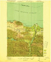 1919 Port Crescent1919 Print · USGSThe northern Olympic Peninsula comes alive in this survey, showing the shoreline from Agate Bay to Freshwater Bay. Trace the early timber economy through the Logging RR and find vanished sites like Port Crescent or the East Beach ferry landing.4 unique versions available
 - 1950 Map of Joyce, 1955 Print
 1950 Joyce1955 Print · USGSThe northern coast of the Olympic Peninsula is captured here in the early 1950s, showing the intersection of military defense and timber-country rail lines. Genealogists and historians can trace the Milwaukee Road through the community of Joyce and locate the Crescent Sch and Camp Hayden.
 - 1950 Map of Joyce, 1960 Print
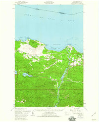 1950 Joyce1960 Print · USGSCoastal Clallam County at mid-century reveals a landscape of working timberlands and emerging mountain parkland. Researchers can trace the Old Piedmont Railroad Grade or locate early settlements like Ramapo, Maple Grove, and Snug Harbor.2 unique versions available
 - 1957 Map of Victoria, 1960 Print
 1957 Victoria1960 Print · USGSThe San Juan Islands and the North Cascades coastline are shown in detail during the late fifties, a period of significant military and industrial presence. Researchers can trace historic rail lines like the Great Northern or locate sites such as the Whidbey Island Naval Air Sta and Friday Harbor.4 unique versions available
 - 1979 Map of Port Angeles
 1979 Port Angeles1979 Print · USGSThe northern Olympic Peninsula and southern Vancouver Island are captured here in the late seventies. Family historians can trace the rail networks of the Esquimalt and Nanaimo Railway or locate old coastal settlements like Sooke, Joyce, and Agnew.
 - 2011 Map of Joyce, 2011 Print
 2011 Joyce2011 Print · USGSCovers Ramapo, including Joyce, Joyce, and other nearby areas
 - 2014 Map of Joyce, 2014 Print
 2014 Joyce2014 Print · USGSCovers Ramapo, including Joyce, Joyce, and other nearby areas
 - 2017 Map of Joyce, 2017 Print
 2017 Joyce2017 Print · USGSCovers Ramapo, including Joyce, Joyce, and other nearby areas
 - 2020 Map of Joyce, 2020 Print
 2020 Joyce2020 Print · USGSCovers Ramapo, including Joyce, Joyce, and other nearby areas
 - 2023 Map of Joyce, 2023 Print
 2023 Joyce2023 Print · USGSThe northern Olympic Peninsula coast comes to life in this recent study of the shoreline between Crescent Bay and Freshwater Bay. Researchers can locate the Port Crescent Pioneer Memorial Cem and trace rural routes through Joyce and Coville.
End of results
Showing maps 1-10 of 10
Top cities near Ramapo
Frequently asked questions
- What are the different types of historical maps available for Ramapo?
- What is the oldest map of Ramapo?
- Where can I purchase historical maps of Ramapo for my home or office?
- Where can I download high-res historical maps of Ramapo?
- Are there historical topographic maps available for Ramapo?
- Is there historical aerial imagery available for Ramapo?
- Where are historical maps of Ramapo sourced from?