Old Maps of Ranger, Washington for Academic Research
Study the evolution of Ranger with 10 high-resolution historic maps. Whether you're teaching, researching, or modeling changes in land use, these maps provide essential visual documentation of urban, environmental, and geographic change.
- Analyze long-term change: Track patterns in development, transportation, and natural features.
- Ideal for environmental or urban studies: Support academic projects with primary historical map data.
- Use in the classroom or lab: Educators and researchers rely on these maps to bring historical context to life.
These maps are a powerful tool for teaching, research, and visualizing how Ranger has changed over the decades.
Ranger, WA maps
(10)- 1919 Map of Port Crescent
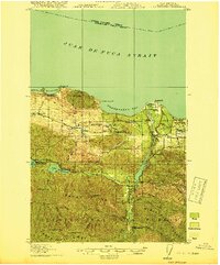 1919 Port Crescent1919 Print · USGSThe northern Olympic Peninsula comes alive in this survey, showing the shoreline from Agate Bay to Freshwater Bay. Trace the early timber economy through the Logging RR and find vanished sites like Port Crescent or the East Beach ferry landing.4 unique versions available
 - 1950 Map of Angeles Point, 1955 Print
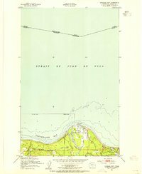 1950 Angeles Point1955 Print · USGSThe Clallam County coast comes into focus during the early fifties, showing the busy maritime and rail activity at the mouth of the Elwha River. Genealogists and researchers can trace the rail lines through Elwha Station or locate the Ocean View Cem near the Clallam County Airport.2 unique versions available
 - 1950 Map of Joyce, 1960 Print
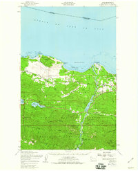 1950 Joyce1960 Print · USGSCoastal Clallam County at mid-century reveals a landscape of working timberlands and emerging mountain parkland. Researchers can trace the Old Piedmont Railroad Grade or locate early settlements like Ramapo, Maple Grove, and Snug Harbor.2 unique versions available
 - 1957 Map of Victoria, 1960 Print
 1957 Victoria1960 Print · USGSThe San Juan Islands and the North Cascades coastline are shown in detail during the late fifties, a period of significant military and industrial presence. Researchers can trace historic rail lines like the Great Northern or locate sites such as the Whidbey Island Naval Air Sta and Friday Harbor.4 unique versions available
 - 1979 Map of Port Angeles
 1979 Port Angeles1979 Print · USGSThe northern Olympic Peninsula and southern Vancouver Island are captured here in the late seventies. Family historians can trace the rail networks of the Esquimalt and Nanaimo Railway or locate old coastal settlements like Sooke, Joyce, and Agnew.
 - 2011 Map of Angeles Point, 2011 Print
 2011 Angeles Point2011 Print · USGSCovers Ranger, including Port Angeles, Elwha Station, and other nearby areas
 - 2014 Map of Angeles Point, 2014 Print
 2014 Angeles Point2014 Print · USGSCovers Ranger, including Port Angeles, Elwha Station, and other nearby areas
 - 2017 Map of Angeles Point, 2017 Print
 2017 Angeles Point2017 Print · USGSCovers Ranger, including Port Angeles, Elwha Station, and other nearby areas
 - 2020 Map of Angeles Point, 2020 Print
 2020 Angeles Point2020 Print · USGSCovers Ranger, including Port Angeles, Elwha Station, and other nearby areas
 - 2023 Map of Angeles Point, 2023 Print
 2023 Angeles Point2023 Print · USGSThe Olympic Peninsula coast comes into focus here, where the Elwha River reaches the Salish Sea. Researchers can trace the community layout of Lower Elwha, find family plots at Ocean View Cem, or locate the William R Fairchild International Airport.
End of results
Showing maps 1-10 of 10
Top cities near Ranger
Frequently asked questions
- What are the different types of historical maps available for Ranger?
- What is the oldest map of Ranger?
- Where can I purchase historical maps of Ranger for my home or office?
- Where can I download high-res historical maps of Ranger?
- Are there historical topographic maps available for Ranger?
- Is there historical aerial imagery available for Ranger?
- Where are historical maps of Ranger sourced from?