1900s (20th Century) Maps of Sequim, Washington
Explore 6 historic maps of Sequim from the 1900s (20th Century). These maps offer a rare glimpse into what life looked like during the 1900s — showing old roads, neighborhoods, homes, and landmarks that have changed or disappeared over time.
Whether you're researching your family's past, planning a metal detecting trip, or studying how Sequim's landscape evolved across the 1900s, these high-resolution maps are a powerful tool for exploring the history of this region.
- Focus on a specific era: All maps on this page are from the 1900s, giving you a focused view of this time period.
- See what’s changed: Compare century-old streets, trails, and buildings to today's modern landscape using overlays and satellite layers.
- Research with precision: Use these maps for genealogy, historical research, land use analysis, or educational projects.
- View, download, or print: Maps are fully viewable online in high resolution, and can be downloaded or printed for your own records.
Start exploring Sequim's history through authentic maps from the 1900s. This is your window into the past.
Sequim, WA maps
(6)- 1938 Map of Dungeness, 1961 Print
 1938 Dungeness1961 Print · USGSThe northern Olympic Peninsula coastline in the late 1930s shows a landscape of coastal ranches and railroad-dependent towns. Researchers can trace early family holdings like the McNair Ranch or locate historical maritime markers such as the Dungeness L. H. and the vanished rail stops of the Chicago Milwaukee St Paul and Pacific.2 unique versions available
 - 1939 Map of Dungeness
 1939 Dungeness1939 Print · USGSCoastal Clallam County comes alive in the late thirties as a landscape of maritime navigation and valley ranching. Genealogists and historians can locate family landmarks like the McNair Ranch, rural schoolhouses such as Carlsborg Sch, and the winding Old Olympia Highway.
 - 1956 Map of Sequim, 1957 Print
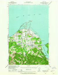
 1956 Sequim1957 Print · USGSThe Olympic Peninsula shoreline meets the agricultural Dungeness Valley in the mid-1950s. Genealogists and local historians can trace family-named sites like Beck Ranch and Grennans Hill, or locate the historic Port Williams (Site) and Jamestown Cemetery.5 unique versions available
 - 1956 Map of Carlsborg, 1958 Print
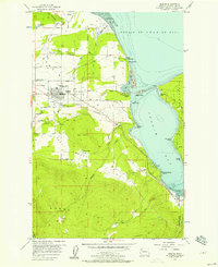
 1956 Carlsborg1958 Print · USGSClallam County’s Dungeness Valley in the mid-fifties shows a landscape of timber mills and rural homesteads at the foot of the Olympic Mountains. Genealogists and historians can trace family road names near Agnew, locate the McCleay Sch (Aban'd), or study the path of the Milwaukee Road.4 unique versions available
 - 1957 Map of Victoria, 1960 Print
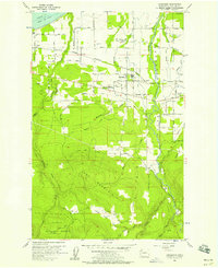
 1957 Victoria1960 Print · USGSThe San Juan Islands and the North Cascades coastline are shown in detail during the late fifties, a period of significant military and industrial presence. Researchers can trace historic rail lines like the Great Northern or locate sites such as the Whidbey Island Naval Air Sta and Friday Harbor.4 unique versions available
 - 1979 Map of Port Angeles
 1979 Port Angeles1979 Print · USGSThe northern Olympic Peninsula and southern Vancouver Island are captured here in the late seventies. Family historians can trace the rail networks of the Esquimalt and Nanaimo Railway or locate old coastal settlements like Sooke, Joyce, and Agnew.
End of results
Showing maps 1-6 of 6
Top cities near Sequim
Frequently asked questions
- What are the different types of historical maps available for Sequim?
- What is the oldest map of Sequim?
- Where can I purchase historical maps of Sequim for my home or office?
- Where can I download high-res historical maps of Sequim?
- Are there historical topographic maps available for Sequim?
- Is there historical aerial imagery available for Sequim?
- Where are historical maps of Sequim sourced from?