Old Maps of Twin, Washington for Metal Detecting
Plan your next treasure hunt with 11 historic maps of Twin. Find old homesites, ghost towns, trails, and gathering spots that may be lost to time — perfect for identifying promising metal detecting locations.
- Locate forgotten sites: Uncover places like long-lost settlements, abandoned rail lines, or gathering spots.
- Plan better hunts: Use map overlays combined with LiDAR or satellite views to narrow in on historically rich areas.
- Made for detectorists: Thousands of hobbyists use these maps to discover relics, coins, and hidden history.
Use these historic maps to boost your research and find new opportunities beneath the surface of Twin.
Twin, WA maps
(11)- 1918 Map of Lake Crescent, 1958 Print
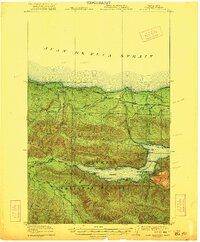
 1918 Lake Crescent1958 Print · USGSThe northern Olympic Peninsula in the early twentieth century was a landscape of deep glacial lakes and heavy timber industry. Genealogists and historians can trace rail-era settlements like Gettysburg and Fairholm, or locate old landmarks like Twin School and the Crescent Lake Tavern.
 - 1922 Map of Lake Crescent
 1922 Lake Crescent1922 Print · USGSCoastal Clallam County at the start of the 1920s shows a rugged landscape of timber railroads and lakeside resorts. Genealogists and historians can locate early landmarks like Twin School, Grubbs Landing, and the Crescent Lake Tavern.3 unique versions available
 - 1950 Map of Twin Rivers, 1955 Print
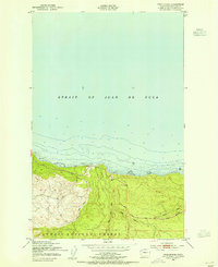 1950 Twin Rivers1955 Print · USGSThe northern coast of the Olympic Peninsula is captured here in the mid-1950s, where the forest meets the sea. Researchers can trace early transport routes like the Port Angeles Neah Bay State Highway and the drainage basins of the West Twin River and East Twin River.4 unique versions available
 - 1950 Map of Lake Crescent, 1960 Print
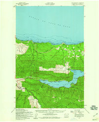 1950 Lake Crescent1960 Print · USGSClallam County at mid-century reveals a landscape of deep timber and glacial lakes during the height of the Olympic Peninsula's logging era. Trace the path of the Old Railroad Grade and locate old lakeside landings at Fairholm, Piedmont, and Ovington.3 unique versions available
 - 1957 Map of Victoria, 1960 Print
 1957 Victoria1960 Print · USGSThe San Juan Islands and the North Cascades coastline are shown in detail during the late fifties, a period of significant military and industrial presence. Researchers can trace historic rail lines like the Great Northern or locate sites such as the Whidbey Island Naval Air Sta and Friday Harbor.4 unique versions available
 - 1979 Map of Port Angeles
 1979 Port Angeles1979 Print · USGSThe northern Olympic Peninsula and southern Vancouver Island are captured here in the late seventies. Family historians can trace the rail networks of the Esquimalt and Nanaimo Railway or locate old coastal settlements like Sooke, Joyce, and Agnew.
 - 2011 Map of Twin Rivers, 2011 Print
 2011 Twin Rivers2011 Print · USGSCovers Twin, including Clallam County, United States, and other nearby areas
 - 2014 Map of Twin Rivers, 2014 Print
 2014 Twin Rivers2014 Print · USGSCovers Twin, including Clallam County, United States, and other nearby areas
 - 2017 Map of Twin Rivers, 2017 Print
 2017 Twin Rivers2017 Print · USGSCovers Twin, including Clallam County, United States, and other nearby areas
 - 2020 Map of Twin Rivers, 2020 Print
 2020 Twin Rivers2020 Print · USGSCovers Twin, including Clallam County, United States, and other nearby areas
 - 2023 Map of Twin Rivers, 2023 Print
 2023 Twin Rivers2023 Print · USGSThe Clallam County coast and the northern Olympic Peninsula are captured in this 2023 survey. Trace the waterfront at Twin or follow the inland paths of the West Twin River and East Twin River into the Olympic National Forest.
End of results
Showing maps 1-11 of 11
Frequently asked questions
- What are the different types of historical maps available for Twin?
- What is the oldest map of Twin?
- Where can I purchase historical maps of Twin for my home or office?
- Where can I download high-res historical maps of Twin?
- Are there historical topographic maps available for Twin?
- Is there historical aerial imagery available for Twin?
- Where are historical maps of Twin sourced from?