1990s Maps of Truman, Clark County
Explore 2 historic maps of Truman from the 1990s. These maps offer a rare glimpse into what life looked like during the 1990s — showing old roads, neighborhoods, homes, and landmarks that have changed or disappeared over time.
Whether you're researching your family's past, planning a metal detecting trip, or studying how Truman's landscape evolved across the 1990s, these high-resolution maps are a powerful tool for exploring the history of this region.
- Focus on a specific era: All maps on this page are from the 1990s, giving you a focused view of this time period.
- See what’s changed: Compare century-old streets, trails, and buildings to today's modern landscape using overlays and satellite layers.
- Research with precision: Use these maps for genealogy, historical research, land use analysis, or educational projects.
- View, download, or print: Maps are fully viewable online in high resolution, and can be downloaded or printed for your own records.
Start exploring Truman's history through authentic maps from the 1990s. This is your window into the past.
Truman, Clark County maps
(2)- 1990 Map of Vancouver, 1995 Print
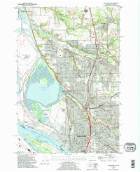 1990 Vancouver1995 Print · USGSVancouver and its Columbia River waterfront are captured here in the 1990s as the city expanded northward toward Salmon Creek. Researchers can locate family plots at Salmon Creek Cem, explore the grounds of Clark College, or trace the rail lines through Vancouver Junction.
 - 1990 Map of Orchards, 1995 Print
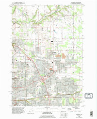 1990 Orchards1995 Print · USGSGreater Vancouver and the Fourth Plains area appear here in the early nineties as the suburban grid expands into traditional farmland. Genealogists and local researchers can locate family sites at St Johns Cem, Elim Ch, and the long-established settlement of Brush Prairie.
End of results
Showing maps 1-2 of 2
Frequently asked questions
- What are the different types of historical maps available for Truman?
- What is the oldest map of Truman?
- Where can I purchase historical maps of Truman for my home or office?
- Where can I download high-res historical maps of Truman?
- Are there historical topographic maps available for Truman?
- Is there historical aerial imagery available for Truman?
- Where are historical maps of Truman sourced from?