1980s Maps of Covada, Washington
Explore 2 historic maps of Covada from the 1980s. These maps offer a rare glimpse into what life looked like during the 1980s — showing old roads, neighborhoods, homes, and landmarks that have changed or disappeared over time.
Whether you're researching your family's past, planning a metal detecting trip, or studying how Covada's landscape evolved across the 1980s, these high-resolution maps are a powerful tool for exploring the history of this region.
- Focus on a specific era: All maps on this page are from the 1980s, giving you a focused view of this time period.
- See what’s changed: Compare century-old streets, trails, and buildings to today's modern landscape using overlays and satellite layers.
- Research with precision: Use these maps for genealogy, historical research, land use analysis, or educational projects.
- View, download, or print: Maps are fully viewable online in high resolution, and can be downloaded or printed for your own records.
Start exploring Covada's history through authentic maps from the 1980s. This is your window into the past.
Covada, WA maps
(2)- 1984 Map of Nespelem
 1984 Nespelem1984 Print · USGSThe Colville Indian Reservation and the Columbia River valley are shown here in the mid-1980s, just as modern recreation was shaping the landscape. Genealogists and researchers can locate old communities like Inchelium and Keller or trace mining history at the Germania Mine.
 - 1985 Map of Cedonia
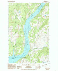 1985 Cedonia1985 Print · USGSThe Columbia River corridor north of Grand Coulee Dam appears here in the mid-1980s as the vast Franklin D. Roosevelt Lake. You can trace the boundary between the Colville Indian Reservation and Stevens County, locating the Longstreet Mine and the small communities of Cedonia and Covada.2 unique versions available
End of results
Showing maps 1-2 of 2
Frequently asked questions
- What are the different types of historical maps available for Covada?
- What is the oldest map of Covada?
- Where can I purchase historical maps of Covada for my home or office?
- Where can I download high-res historical maps of Covada?
- Are there historical topographic maps available for Covada?
- Is there historical aerial imagery available for Covada?
- Where are historical maps of Covada sourced from?