1940s Maps of Peola, Washington
Explore 2 historic maps of Peola from the 1940s. These maps offer a rare glimpse into what life looked like during the 1940s — showing old roads, neighborhoods, homes, and landmarks that have changed or disappeared over time.
Whether you're researching your family's past, planning a metal detecting trip, or studying how Peola's landscape evolved across the 1940s, these high-resolution maps are a powerful tool for exploring the history of this region.
- Focus on a specific era: All maps on this page are from the 1940s, giving you a focused view of this time period.
- See what’s changed: Compare century-old streets, trails, and buildings to today's modern landscape using overlays and satellite layers.
- Research with precision: Use these maps for genealogy, historical research, land use analysis, or educational projects.
- View, download, or print: Maps are fully viewable online in high resolution, and can be downloaded or printed for your own records.
Start exploring Peola's history through authentic maps from the 1940s. This is your window into the past.
Peola, WA maps
(2)- 1943 Map of Peola
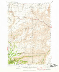 1943 Peola1943 Print · USGSSoutheast Washington’s plateau and canyon country are captured here in the 1940s, showing the intersection of mountain timber and ranch land. Researchers can find old district schoolhouses like Philomathian Sch and trace family holdings such as Armstrong Ranch or the Iron Springs Guard Sta.
 - 1946 Map of Peola
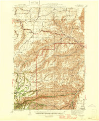 1946 Peola1946 Print · USGSGarfield County ranching and timber lands are captured here just after the war, showing a landscape of remote homesteads and mountain ridges. Genealogists can trace family landmarks like Robinson Ranch or rural school sites such as Philomathian Sch and School No 18.
End of results
Showing maps 1-2 of 2
Top cities near Peola
Frequently asked questions
- What are the different types of historical maps available for Peola?
- What is the oldest map of Peola?
- Where can I purchase historical maps of Peola for my home or office?
- Where can I download high-res historical maps of Peola?
- Are there historical topographic maps available for Peola?
- Is there historical aerial imagery available for Peola?
- Where are historical maps of Peola sourced from?