1900s (20th Century) Maps of Mattawa, Washington
Explore 8 historic maps of Mattawa from the 1900s (20th Century). These maps offer a rare glimpse into what life looked like during the 1900s — showing old roads, neighborhoods, homes, and landmarks that have changed or disappeared over time.
Whether you're researching your family's past, planning a metal detecting trip, or studying how Mattawa's landscape evolved across the 1900s, these high-resolution maps are a powerful tool for exploring the history of this region.
- Focus on a specific era: All maps on this page are from the 1900s, giving you a focused view of this time period.
- See what’s changed: Compare century-old streets, trails, and buildings to today's modern landscape using overlays and satellite layers.
- Research with precision: Use these maps for genealogy, historical research, land use analysis, or educational projects.
- View, download, or print: Maps are fully viewable online in high resolution, and can be downloaded or printed for your own records.
Start exploring Mattawa's history through authentic maps from the 1900s. This is your window into the past.
Mattawa, WA maps
(8)- 1917 Map of Priest Rapids
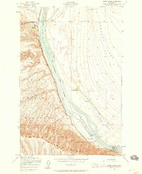
 1917 Priest Rapids1917 Print · USGSThe Columbia River bend and the high country of the Rattlesnake Hills are captured here during a period of early ranching and river industry. Genealogists and historians can locate remote outposts like Figure 2 Ranch, the site of Vernita, and the vital Richmond Ferry.2 unique versions available
 - 1948 Map of Priest Rapids, 1958 Print
 1948 Priest Rapids1958 Print · USGSThe Columbia River corridor is captured here in the late 1940s, split between the Yakima Firing Center Military Reservation and the Wahluke Slope. Researchers can trace the river's path through Priest Rapids, locating family sites like Stewart Ranch and the early Powerhouse.2 unique versions available
 - 1951 Map of Priest Rapids
 1951 Priest Rapids1951 Print · USGSThe Columbia River and its powerful rapids dominate this landscape during the early fifties, before modern development transformed the river valley. Genealogists and researchers can trace ranching heritage at the Taylor Ranch or locate the Black Rock Cem.
 - 1953 Map of Walla Walla, 1964 Print
 1953 Walla Walla1964 Print · USGSSoutheast Washington enters the atomic and hydroelectric age in the mid-twentieth century as new dams reshape the desert landscape. You can trace the development of the Hanford Works, identify remote rail stops like Novara Siding, and locate the historic Dry Creek Cem.3 unique versions available
 - 1958 Map of Walla Walla
 1958 Walla Walla1958 Print · USGSThe Tri-Cities and Walla Walla region are captured here during the mid-century expansion of atomic energy and river infrastructure. Genealogists and historians can trace the early layout of Richland (AEC), the rural Hatton and Washtucna settlements, and landmarks like Palouse Falls State Park.
 - 1965 Map of Priest Rapids, 1966 Print
 1965 Priest Rapids1966 Print · USGSThe Columbia River bend underwent a profound transformation in the 1960s as hydroelectric power and federal projects reshaped the desert landscape. Genealogists and historians can trace family locations like Meeboor Ranch or the Black Rock Cem alongside the massive Priest Rapids Dam.
 - 1979 Map of Priest Rapids
 1979 Priest Rapids1979 Print · USGSThe Columbia River basin in the late seventies reveals a landscape shaped by massive federal projects and rail expansion. Trace the Hanford Works perimeter, the Priest Rapids Dam, and the early growth of Royal City and Othello.2 unique versions available
 - 1986 Map of Priest Rapids NE
 1986 Priest Rapids NE1986 Print · USGSThe Columbia River shoreline and the sprawling Hanford Site are captured here in the mid-eighties as industry and conservation met. Researchers can trace the path of the Wahluke Branch Canal or locate landmarks like Arrowsmith At and the Gaging Station.
End of results
Showing maps 1-8 of 8
Top cities near Mattawa
Frequently asked questions
- What are the different types of historical maps available for Mattawa?
- What is the oldest map of Mattawa?
- Where can I purchase historical maps of Mattawa for my home or office?
- Where can I download high-res historical maps of Mattawa?
- Are there historical topographic maps available for Mattawa?
- Is there historical aerial imagery available for Mattawa?
- Where are historical maps of Mattawa sourced from?