Old Maps of Grant County, Washington
Explore 535 old maps of Grant County, spanning from 1909 to today. These high-resolution historic maps reveal how streets, neighborhoods, landmarks, and natural features evolved over time — perfect for genealogy, metal detecting, research, and local history exploration.
What you can do with these maps:
- See how Grant County changed over time: Compare historical maps to modern-day views to trace roads, homesites, rail lines & more.
- View detailed metadata: Each map includes creators, publishers, year, scale, and archive source.
- Overlay maps with satellite & LiDAR: Visualize the past alongside modern tools to explore terrain & human change.
- Trusted historical sources: Maps sourced from the USGS, Library of Congress, and other archives.
- Access maps your way: View online, download high-res files, or order prints for personal or research use.
Start exploring old maps of Grant County to uncover forgotten places, hidden landmarks, and the deep history beneath your feet.
Grant County, WA maps
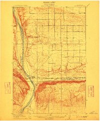
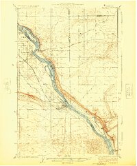
(535)- 1909 Map of Quincy, 1965 Print
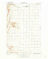 1909 Quincy1965 Print · USGSCentral Washington's high desert reveals its early rail and ranching roots just after the turn of the century. Trace the old rural schoolhouse network from Mountain View School to Glendale School and the growing town of Quincy along the Great Northern RR.
 - 1910 Map of Quincy
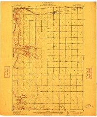 1910 Quincy1910 Print · USGSGrant County is captured in a moment of early expansion as homesteaders settled the basin during the first decade of the century. Genealogists can trace family roots through numerous rural landmarks like Evergreen School, Burke, and Haywood School.4 unique versions available
 - 1910 Map of Winchester
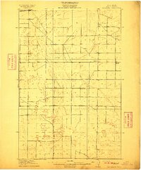 1910 Winchester1910 Print · USGSGrant County is captured in the early twentieth century as rural homesteaders began to settle the semi-arid landscape along the Great Northern RR. Researchers can locate early rural landmarks including Winchester and five distinct schools such as Dishaw School and McEwen School.3 unique versions available
 - 1911 Map of Red Rock
 1911 Red Rock1911 Print · USGSGrant County is captured during the arrival of the transcontinental railroad in the early twentieth century. Genealogists and researchers can trace the early rail stops at Smyrna and Colletta or locate rural landmarks like Sumner School and Joyces Ranch.2 unique versions available
 - 1912 Map of Moses Lake
 1912 Moses Lake1912 Print · USGSGrant County is captured in the early twentieth century before the major irrigation projects reshaped the desert. Genealogists can locate family holdings near Mae or trace the early paths to Hiawatha School and the unique geography of The Potholes.6 unique versions available
 - 1912 Map of Beverly
 1912 Beverly1912 Print · USGSCentral Washington is captured here at a pivotal moment just after the arrival of the railroad. You can trace the path of the Chicago Milwaukee and Puget Sound RR through riverfront settlements like Beverly and Cohassett.6 unique versions available
 - 1912 Map of Malaga
 1912 Malaga1912 Print · USGSCentral Washington's river-driven development is on display here just before the era of major hydroelectric projects. Genealogists and historians can trace an incredible density of early schools like Lower Stemilt School and settlements like Malaga and Vulcan.2 unique versions available
 - 1914 Map of Malaga
 1914 Malaga1914 Print · USGSCentral Washington ranching and rail life are captured here just before World War I, centered on the Columbia River corridor. Genealogists and local historians can locate early homesteads and landmarks like the Sheehan Ranch, Malaga, and Liberty School.3 unique versions available
 - 1916 Map of Connell
 1916 Connell1916 Print · USGSIn the decade before the region's landscape was further transformed by modern irrigation, this area shows a dense network of early schoolhouses and railroad stops. Genealogists can trace family footprints through sites like Roxboro School, Hatton, and Kahlotus along the Washtucna Lake shoreline.
 - 1916 Map of Coyote Rapids
 1916 Coyote Rapids1916 Print · USGSBenton and Grant counties meet along a wild stretch of the Columbia River during the mid-1910s. Researchers can trace the early railroad stops at Allard and Haven, the site of Coyote Rapids, and the irrigation works of the Benson Ditch.3 unique versions available
 - 1917 Map of Priest Rapids
 1917 Priest Rapids1917 Print · USGSThe Columbia River bend and the high country of the Rattlesnake Hills are captured here during a period of early ranching and river industry. Genealogists and historians can locate remote outposts like Figure 2 Ranch, the site of Vernita, and the vital Richmond Ferry.2 unique versions available
 - 1918 Map of Connell
 1918 Connell1918 Print · USGSEastern Washington at the end of the Great War era shows a landscape shaped by emerging railroads and a dense network of rural school districts. Genealogists and historians can trace family-named sites across Paradise Flats and locate early community hubs like Kahlotus, Connell, and Stephenson School.
 - 1920 Map of Colockum Pass
 1920 Colockum Pass1920 Print · USGSKittitas and Douglas counties are shown during a time of river ferries and mountain ranching. You can trace early schoolhouse locations like Whisky Dick School and follow the old Trinidad Ferry route across the Columbia River.
 - 1922 Map of Colockum Pass
 1922 Colockum Pass1922 Print · USGSEastern Washington ranching and river commerce are captured here just after the Great War, showing a landscape of high mountain passes and vital Columbia River crossings. Genealogists can trace family homesteads like Sheridan Ranch and local rural landmarks including Whisky Dick School and the Trinidad Ferry.2 unique versions available
 - 1923 Map of Corfu
 1923 Corfu1923 Print · USGSThe high desert of Grant and Adams counties comes into focus in the early twenties, during the height of the transcontinental rail era. Genealogists and historians can locate rural landmarks like Hope Valley School and the rail stops at Corfu and Taunton.
 - 1923 Map of Wheeler, 1952 Print
 1923 Wheeler1952 Print · USGSThe rural landscape of central Washington comes alive in the early 1920s as a major crossroads for competing rail lines. Genealogists and historians can trace numerous remote country schoolhouses like Keller School and Plain View School alongside rail stops at Ruff and Wheeler.
 - 1924 Map of Othello
 1924 Othello1924 Print · USGSThe Columbia Basin during the mid-1920s shows a landscape of pioneering rail towns and remote schoolhouses. Genealogists and historians can trace family locations through rural landmarks like ADAMS CEM, Billington School, and the rail stops at Bruce and Hamlet Spur.2 unique versions available
 - 1924 Map of Hanford
 1924 Hanford1924 Print · USGSThe Columbia River valley in the early 1920s was a landscape of pioneering ranches and riverfront towns long before the atomic age. Genealogists and historians can trace the foundations of Hanford and White Bluffs, or locate rural landmarks like the Brick School and Maplehurst Ranch.2 unique versions available
 - 1925 Map of Wheeler
 1925 Wheeler1925 Print · USGSThe Grant County prairie in the mid-twenties shows a landscape dominated by the high-desert rail economy and rural education. Researchers can trace the legacy of early homesteaders through local landmarks like Wheeler School, Bassett Junction, and Nagel.
 - 1925 Map of Schrag
 1925 Schrag1925 Print · USGSAdams County’s high desert plateau comes alive in the mid-twenties, showing a landscape of scattered grain elevators and family-named landmarks. Trace early rail life through Batum and Schrag, or locate rural schoolhouses like High Valley School and the Janke School.2 unique versions available
 - 1930 Map of Grand Coulee Sheet 3
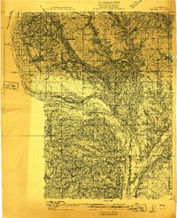
 1930 Grand Coulee Sheet 31930 Print · USGSGrant County is captured during a period of transition in the late twenties, showing the area's complex geology before major development. Researchers can trace local landmarks like the Grand View Sch and the significant geological formation of the Bacon Monocline.
 - 1939 Map of Boylston
 1939 Boylston1939 Print · USGSKittitas County's high desert landscape is captured here in the late 1930s as steam-era rail lines and early highways traversed the basalt ridges. Researchers can trace the Milwaukee St Paul and Pacific tracks past Boylston and locate remote water sources like Whisky Dick Creek and MaDonald Spr.
 - 1943 Map of Boylston
 1943 Boylston1943 Print · USGSKittitas County is shown here during the early 1940s as a landscape of remote rail stops and geological wonders. Trace the path of the Milwaukee St Paul and Pacific through Boylston and find the early boundaries of Ginkgo Petrified Forest State Park.2 unique versions available
 - 1948 Map of Grand Coulee Dam, 1955 Print
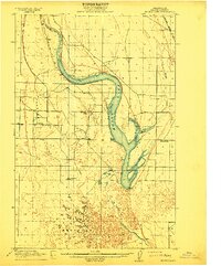
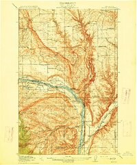
 1948 Grand Coulee Dam1955 Print · USGSThe Grand Coulee region underwent a massive transformation by the late 1940s as the dam transformed the river valley into a sprawling reservoir. Trace the growth of Coulee Dam and Grand Coulee, and locate rural landmarks like the Grand Coulee Grange and Bagdad Junction.6 unique versions available
 - 1948 Map of Priest Rapids, 1958 Print
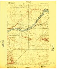
 1948 Priest Rapids1958 Print · USGSThe Columbia River corridor is captured here in the late 1940s, split between the Yakima Firing Center Military Reservation and the Wahluke Slope. Researchers can trace the river's path through Priest Rapids, locating family sites like Stewart Ranch and the early Powerhouse.2 unique versions available
Showing maps 1-25 of 535
Top cities of Grant County
- Moses Lake historical maps
- Ephrata historical maps
- Quincy historical maps
- Mattawa historical maps
- Warden historical maps
- Royal City historical maps
See more
Frequently asked questions
- What are the different types of historical maps available for Grant County?
- What is the oldest map of Grant County?
- Where can I purchase historical maps of Grant County for my home or office?
- Where can I download high-res historical maps of Grant County?
- Are there historical topographic maps available for Grant County?
- Is there historical aerial imagery available for Grant County?
- Where are historical maps of Grant County sourced from?