1910s Maps of Grant County, Washington
Explore 11 historic maps of Grant County from the 1910s. These maps offer a rare glimpse into what life looked like during the 1910s — showing old roads, neighborhoods, homes, and landmarks that have changed or disappeared over time.
Whether you're researching your family's past, planning a metal detecting trip, or studying how Grant County's landscape evolved across the 1910s, these high-resolution maps are a powerful tool for exploring the history of this region.
- Focus on a specific era: All maps on this page are from the 1910s, giving you a focused view of this time period.
- See what’s changed: Compare century-old streets, trails, and buildings to today's modern landscape using overlays and satellite layers.
- Research with precision: Use these maps for genealogy, historical research, land use analysis, or educational projects.
- View, download, or print: Maps are fully viewable online in high resolution, and can be downloaded or printed for your own records.
Start exploring Grant County's history through authentic maps from the 1910s. This is your window into the past.
Grant County, WA maps
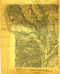
(11)- 1910 Map of Quincy
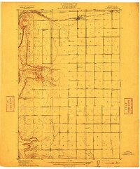 1910 Quincy1910 Print · USGSGrant County is captured in a moment of early expansion as homesteaders settled the basin during the first decade of the century. Genealogists can trace family roots through numerous rural landmarks like Evergreen School, Burke, and Haywood School.4 unique versions available
 - 1910 Map of Winchester
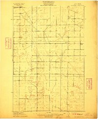 1910 Winchester1910 Print · USGSGrant County is captured in the early twentieth century as rural homesteaders began to settle the semi-arid landscape along the Great Northern RR. Researchers can locate early rural landmarks including Winchester and five distinct schools such as Dishaw School and McEwen School.3 unique versions available
 - 1911 Map of Red Rock
 1911 Red Rock1911 Print · USGSGrant County is captured during the arrival of the transcontinental railroad in the early twentieth century. Genealogists and researchers can trace the early rail stops at Smyrna and Colletta or locate rural landmarks like Sumner School and Joyces Ranch.2 unique versions available
 - 1912 Map of Moses Lake
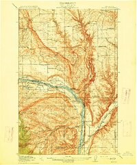
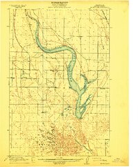 1912 Moses Lake1912 Print · USGSGrant County is captured in the early twentieth century before the major irrigation projects reshaped the desert. Genealogists can locate family holdings near Mae or trace the early paths to Hiawatha School and the unique geography of The Potholes.6 unique versions available
 - 1912 Map of Beverly
 1912 Beverly1912 Print · USGSCentral Washington is captured here at a pivotal moment just after the arrival of the railroad. You can trace the path of the Chicago Milwaukee and Puget Sound RR through riverfront settlements like Beverly and Cohassett.6 unique versions available
 - 1912 Map of Malaga
 1912 Malaga1912 Print · USGSCentral Washington's river-driven development is on display here just before the era of major hydroelectric projects. Genealogists and historians can trace an incredible density of early schools like Lower Stemilt School and settlements like Malaga and Vulcan.2 unique versions available
 - 1914 Map of Malaga
 1914 Malaga1914 Print · USGSCentral Washington ranching and rail life are captured here just before World War I, centered on the Columbia River corridor. Genealogists and local historians can locate early homesteads and landmarks like the Sheehan Ranch, Malaga, and Liberty School.3 unique versions available
 - 1916 Map of Connell
 1916 Connell1916 Print · USGSIn the decade before the region's landscape was further transformed by modern irrigation, this area shows a dense network of early schoolhouses and railroad stops. Genealogists can trace family footprints through sites like Roxboro School, Hatton, and Kahlotus along the Washtucna Lake shoreline.
 - 1916 Map of Coyote Rapids
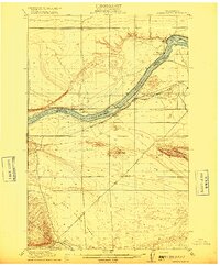 1916 Coyote Rapids1916 Print · USGSBenton and Grant counties meet along a wild stretch of the Columbia River during the mid-1910s. Researchers can trace the early railroad stops at Allard and Haven, the site of Coyote Rapids, and the irrigation works of the Benson Ditch.3 unique versions available
 - 1917 Map of Priest Rapids
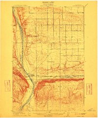
 1917 Priest Rapids1917 Print · USGSThe Columbia River bend and the high country of the Rattlesnake Hills are captured here during a period of early ranching and river industry. Genealogists and historians can locate remote outposts like Figure 2 Ranch, the site of Vernita, and the vital Richmond Ferry.2 unique versions available
 - 1918 Map of Connell
 1918 Connell1918 Print · USGSEastern Washington at the end of the Great War era shows a landscape shaped by emerging railroads and a dense network of rural school districts. Genealogists and historians can trace family-named sites across Paradise Flats and locate early community hubs like Kahlotus, Connell, and Stephenson School.
End of results
Showing maps 1-11 of 11
Top cities of Grant County
- Moses Lake historical maps
- Ephrata historical maps
- Quincy historical maps
- Mattawa historical maps
- Warden historical maps
- Royal City historical maps
See more
Frequently asked questions
- What are the different types of historical maps available for Grant County?
- What is the oldest map of Grant County?
- Where can I purchase historical maps of Grant County for my home or office?
- Where can I download high-res historical maps of Grant County?
- Are there historical topographic maps available for Grant County?
- Is there historical aerial imagery available for Grant County?
- Where are historical maps of Grant County sourced from?