1930s Maps of Grant County, Washington
Explore 2 historic maps of Grant County from the 1930s. These maps offer a rare glimpse into what life looked like during the 1930s — showing old roads, neighborhoods, homes, and landmarks that have changed or disappeared over time.
Whether you're researching your family's past, planning a metal detecting trip, or studying how Grant County's landscape evolved across the 1930s, these high-resolution maps are a powerful tool for exploring the history of this region.
- Focus on a specific era: All maps on this page are from the 1930s, giving you a focused view of this time period.
- See what’s changed: Compare century-old streets, trails, and buildings to today's modern landscape using overlays and satellite layers.
- Research with precision: Use these maps for genealogy, historical research, land use analysis, or educational projects.
- View, download, or print: Maps are fully viewable online in high resolution, and can be downloaded or printed for your own records.
Start exploring Grant County's history through authentic maps from the 1930s. This is your window into the past.
Grant County, WA maps
(2)- 1930 Map of Grand Coulee Sheet 3
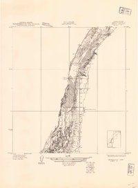 1930 Grand Coulee Sheet 31930 Print · USGSGrant County is captured during a period of transition in the late twenties, showing the area's complex geology before major development. Researchers can trace local landmarks like the Grand View Sch and the significant geological formation of the Bacon Monocline.
 - 1939 Map of Boylston
 1939 Boylston1939 Print · USGSKittitas County's high desert landscape is captured here in the late 1930s as steam-era rail lines and early highways traversed the basalt ridges. Researchers can trace the Milwaukee St Paul and Pacific tracks past Boylston and locate remote water sources like Whisky Dick Creek and MaDonald Spr.
End of results
Showing maps 1-2 of 2
Top cities of Grant County
- Moses Lake historical maps
- Ephrata historical maps
- Quincy historical maps
- Mattawa historical maps
- Warden historical maps
- Royal City historical maps
See more
Frequently asked questions
- What are the different types of historical maps available for Grant County?
- What is the oldest map of Grant County?
- Where can I purchase historical maps of Grant County for my home or office?
- Where can I download high-res historical maps of Grant County?
- Are there historical topographic maps available for Grant County?
- Is there historical aerial imagery available for Grant County?
- Where are historical maps of Grant County sourced from?