1920s Maps of Grant County, Washington
Explore 8 historic maps of Grant County from the 1920s. These maps offer a rare glimpse into what life looked like during the 1920s — showing old roads, neighborhoods, homes, and landmarks that have changed or disappeared over time.
Whether you're researching your family's past, planning a metal detecting trip, or studying how Grant County's landscape evolved across the 1920s, these high-resolution maps are a powerful tool for exploring the history of this region.
- Focus on a specific era: All maps on this page are from the 1920s, giving you a focused view of this time period.
- See what’s changed: Compare century-old streets, trails, and buildings to today's modern landscape using overlays and satellite layers.
- Research with precision: Use these maps for genealogy, historical research, land use analysis, or educational projects.
- View, download, or print: Maps are fully viewable online in high resolution, and can be downloaded or printed for your own records.
Start exploring Grant County's history through authentic maps from the 1920s. This is your window into the past.
Grant County, WA maps
(8)- 1920 Map of Colockum Pass
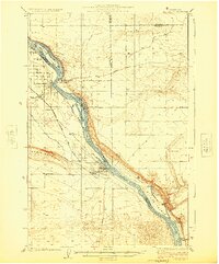
 1920 Colockum Pass1920 Print · USGSKittitas and Douglas counties are shown during a time of river ferries and mountain ranching. You can trace early schoolhouse locations like Whisky Dick School and follow the old Trinidad Ferry route across the Columbia River.
 - 1922 Map of Colockum Pass
 1922 Colockum Pass1922 Print · USGSEastern Washington ranching and river commerce are captured here just after the Great War, showing a landscape of high mountain passes and vital Columbia River crossings. Genealogists can trace family homesteads like Sheridan Ranch and local rural landmarks including Whisky Dick School and the Trinidad Ferry.2 unique versions available
 - 1923 Map of Corfu
 1923 Corfu1923 Print · USGSThe high desert of Grant and Adams counties comes into focus in the early twenties, during the height of the transcontinental rail era. Genealogists and historians can locate rural landmarks like Hope Valley School and the rail stops at Corfu and Taunton.
 - 1923 Map of Wheeler, 1952 Print
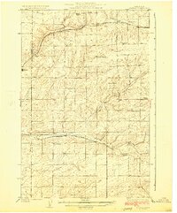
 1923 Wheeler1952 Print · USGSThe rural landscape of central Washington comes alive in the early 1920s as a major crossroads for competing rail lines. Genealogists and historians can trace numerous remote country schoolhouses like Keller School and Plain View School alongside rail stops at Ruff and Wheeler.
 - 1924 Map of Othello
 1924 Othello1924 Print · USGSThe Columbia Basin during the mid-1920s shows a landscape of pioneering rail towns and remote schoolhouses. Genealogists and historians can trace family locations through rural landmarks like ADAMS CEM, Billington School, and the rail stops at Bruce and Hamlet Spur.2 unique versions available
 - 1924 Map of Hanford
 1924 Hanford1924 Print · USGSThe Columbia River valley in the early 1920s was a landscape of pioneering ranches and riverfront towns long before the atomic age. Genealogists and historians can trace the foundations of Hanford and White Bluffs, or locate rural landmarks like the Brick School and Maplehurst Ranch.2 unique versions available
 - 1925 Map of Wheeler
 1925 Wheeler1925 Print · USGSThe Grant County prairie in the mid-twenties shows a landscape dominated by the high-desert rail economy and rural education. Researchers can trace the legacy of early homesteaders through local landmarks like Wheeler School, Bassett Junction, and Nagel.
 - 1925 Map of Schrag
 1925 Schrag1925 Print · USGSAdams County’s high desert plateau comes alive in the mid-twenties, showing a landscape of scattered grain elevators and family-named landmarks. Trace early rail life through Batum and Schrag, or locate rural schoolhouses like High Valley School and the Janke School.2 unique versions available
End of results
Showing maps 1-8 of 8
Top cities of Grant County
- Moses Lake historical maps
- Ephrata historical maps
- Quincy historical maps
- Mattawa historical maps
- Warden historical maps
- Royal City historical maps
See more
Frequently asked questions
- What are the different types of historical maps available for Grant County?
- What is the oldest map of Grant County?
- Where can I purchase historical maps of Grant County for my home or office?
- Where can I download high-res historical maps of Grant County?
- Are there historical topographic maps available for Grant County?
- Is there historical aerial imagery available for Grant County?
- Where are historical maps of Grant County sourced from?