
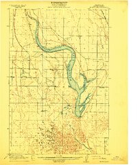
1925 Map of Wheeler
USGS Topo · Published 1925About this map
The northern Grant County prairie of the mid-1920s is defined by a dense network of rural one-room schoolhouses and the crossing of major transcontinental railroads. Educational life centered on scattered districts like Black Rock School, Zeigler School, and Loeffelbein School, which served the farming families established across this landscape. The infrastructure of the Pacific Northwest is evident in the path of the Northern Pacific and the Chicago Milwaukee and St. Paul railroads. These lines intersect at Bassett Junction, forming a vital transportation hub for small agricultural settlements such as Wheeler, Ruff, and Tiflis. Natural drainages like Rocky Coulee and Weber Coulee provide the primary relief to the terrain, while localized sidings and spurs, including Atwood Siding and McDonald Spur, highlight the deep integration of the rail economy into daily life before the expansion of modern highways.
Find a feature on this map
26 named features on this map. Tap any name to fly to it.
Don’t see what you’re looking for? This feature index may not catch every label — zoom into the map to look around manually.
Map Details
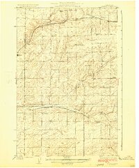
Editions of this 1925 Wheeler Map
This is the sole edition of this map. No revisions or reprints were ever made.
Other maps of this area
1912 · Moses Lake
USGS Topo · 1:62,500

1916 · Connell
USGS Topo · 1:125,000

1918 · Connell
USGS Topo · 1:125,000

1923 · Corfu
USGS Topo · 1:62,500

1923 · Wheeler
USGS Topo · 1:62,500

1924 · Othello
USGS Topo · 1:62,500
1925 · Schrag
USGS Topo · 1:62,500

1951 · Corfu
USGS Topo · 1:62,500

1953 · Walla Walla
USGS Topo · 1:250,000

1953 · Ritzville
USGS Topo · 1:250,000