
1918 Map of Connell
USGS Topo · Published 1918About this map
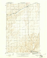
Connell serves as the focal point of this 1916 survey, situated at a junction where multiple rail lines converge amidst the coulees of eastern Washington. The landscape is defined by the prehistoric drainage patterns of the Lind Coulee and Washtuena Coulee, which cut through the broad agricultural expanses of Michigan Prairie and Paradise Flats. The map reveals a robust rural infrastructure from the early twentieth century, evidenced by a high density of country schoolhouses such as Campbell School, Stephenson School, and Lone Star School. Transportation is dominated by the Northern Pacific and the Oregon-Washington Railroad & Navigation Co, which facilitated the movement of grain and goods through rail stops like Hatton, Cunningham, and Kahlotus. Water remains a vital but sparse resource, anchored by features like Sulphur Lake and Washtuena Lake.
Find a feature on this map
70 named features on this map. Tap any name to fly to it.
Don’t see what you’re looking for? This feature index may not catch every label — zoom into the map to look around manually.
Map Details
Editions of this 1918 Connell Map
This is the sole edition of this map. No revisions or reprints were ever made.
Other maps of this area

1915 · Wallulah
USGS Topo · 1:96,000

1916 · Connell
USGS Topo · 1:125,000

1917 · Pasco
USGS Topo · 1:125,000

1918 · Wallula
USGS Topo · 1:125,000

1919 · Walla Walla
USGS Topo · 1:125,000

1921 · Walla Walla
USGS Topo · 1:125,000
1923 · Washtucna
USGS Topo · 1:62,500

1923 · Wheeler
USGS Topo · 1:62,500

1924 · Othello
USGS Topo · 1:62,500

1925 · Wheeler
USGS Topo · 1:62,500