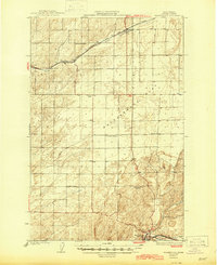
1923 Map of Washtucna
USGS Topo · Published 1923About this map
Washtucna and the surrounding high desert of Adams County are defined by a complex network of early 20th-century transportation and local education. Three major railroads—the Union Pacific, Chicago Milwaukee St Paul and Pacific, and Spokane Portland and Seattle—converge and cross this landscape, illustrating the region's importance as a rail corridor during the 1920s. The settlement of Ralston sits along the northern rail line near Lind Coulee, while the town of Lind anchors the western edge.
Find a feature on this map
15 named features on this map. Tap any name to fly to it.
Don’t see what you’re looking for? This feature index may not catch every label — zoom into the map to look around manually.
Map Details
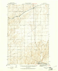
Editions of this 1923 Washtucna Map
This is the sole edition of this map. No revisions or reprints were ever made.