
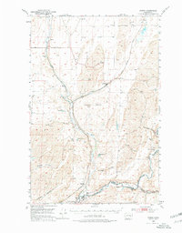
1950 Map of Benge
USGS Topo · Published 1970About this map
Cow Creek winds through the basalt-coulee landscape of the eastern Columbia Basin, defining the corridor for the settlement at Benge. This mid-century survey captures a critical junction of transportation history where the Old Military Trail intersects with the modern engineering of the Spokane Portland and Seattle and Union Pacific railroads. In the southern portion of the quadrangle, the Palouse River carves a deep valley, creating a natural boundary between Adams and Whitman counties.
Find a feature on this map
24 named features on this map. Tap any name to fly to it.
Don’t see what you’re looking for? This feature index may not catch every label — zoom into the map to look around manually.
Map Details
Editions of this 1950 Benge Map
2 editions found
Other maps of this area

1923 · Washtucna
USGS Topo · 1:62,500

1925 · Washtucna
USGS Topo · 1:62,500

1948 · Starbuck
USGS Topo · 1:62,500

1948 · Ayer
USGS Topo · 1:62,500

1950 · La Crosse
USGS Topo · 1:62,500

1950 · Starbuck
USGS Topo · 1:62,500

1950 · Haas
USGS Topo · 1:62,500

1950 · Hay
USGS Topo · 1:62,500

1952 · Hay
USGS Topo · 1:62,500

1952 · La Crosse
USGS Topo · 1:62,500