
1916 Map of Connell
USGS Topo · Published 1916About this map
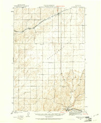
Michigan Prairie and the surrounding coulee-riddled landscape of Eastern Washington define this 1916 survey, a time when small rural schoolhouses served as the primary social anchors for homesteading families. The region is marked by an extensive network of school districts, including Michigan Prairie School, Kansas Prairie School, and Delaney School, reflecting the distribution of early twentieth-century dryland farming communities. The town of Connell serves as a central hub where the Northern Pacific and Oregon-Washington Railroad and Navigation Co lines converge, facilitating the transport of grain from the surrounding flats.
Find a feature on this map
72 named features on this map. Tap any name to fly to it.
Don’t see what you’re looking for? This feature index may not catch every label — zoom into the map to look around manually.
Map Details
Editions of this 1916 Connell Map
This is the sole edition of this map. No revisions or reprints were ever made.
Other maps of this area

1915 · Wallulah
USGS Topo · 1:96,000

1917 · Pasco
USGS Topo · 1:125,000

1918 · Connell
USGS Topo · 1:125,000

1918 · Wallula
USGS Topo · 1:125,000

1919 · Walla Walla
USGS Topo · 1:125,000

1921 · Walla Walla
USGS Topo · 1:125,000
1923 · Washtucna
USGS Topo · 1:62,500

1923 · Wheeler
USGS Topo · 1:62,500

1924 · Othello
USGS Topo · 1:62,500

1925 · Wheeler
USGS Topo · 1:62,500