
1919 Map of Walla Walla
USGS Topo · Published 1964About this map
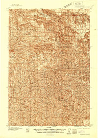
The Walla Walla valley and the surrounding agricultural uplands are captured here following a 1919 survey, showcasing a landscape defined by wheat farming and a dense network of early 20th-century rail lines. The Oregon-Washington Railroad & Navigation Co and the Northern Pacific crisscross the region, connecting small grain-handling settlements like Prescott, Waitsburg, and Huntsville. The map details the local infrastructure of the era, from the State Penitentiary at the edge of the city to the Whitman National Monument near College Place.
Find a feature on this map
101 named features on this map. Tap any name to fly to it.
Don’t see what you’re looking for? This feature index may not catch every label — zoom into the map to look around manually.
Map Details
Editions of this 1919 Walla Walla Map
This is the sole edition of this map. No revisions or reprints were ever made.
Other maps of this area

1915 · Wallulah
USGS Topo · 1:96,000

1916 · Connell
USGS Topo · 1:125,000

1918 · Connell
USGS Topo · 1:125,000

1918 · Wallula
USGS Topo · 1:125,000

1921 · Walla Walla
USGS Topo · 1:125,000

1935 · Pendleton
USGS Topo · 1:125,000
1937 · Pomeroy
USGS Topo · 1:96,000
1942 · Pomeroy
USGS Topo · 1:125,000
1948 · Starbuck
USGS Topo · 1:62,500

1948 · Ayer
USGS Topo · 1:62,500