
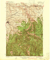
1942 Map of Pomeroy
USGS Topo · Published 1942About this map
Pomeroy and Dayton anchor this survey of the northern Blue Mountains region just before the mid-century, where the Union Pacific railroad connects these agricultural hubs to the wider world. The landscape transition from the dry, rolling uplands of Dutch Flat and Pataha Flat into the deeply incised canyons of the Tucannon River and Pataha Creek is clearly documented. Numerous rural schools, such as Jackson Sch, Skyhawk Sch, and Green Valley Sch, are scattered throughout the drainages, marking the distributed nature of early homesteading and ranching in Garfield and Columbia Counties.
Find a feature on this map
103 named features on this map. Tap any name to fly to it.
Don’t see what you’re looking for? This feature index may not catch every label — zoom into the map to look around manually.
Map Details
Editions of this 1942 Pomeroy Map
2 editions found
Other maps of this area

1910 · Pullman
USGS Topo · 1:125,000

1919 · Walla Walla
USGS Topo · 1:125,000

1921 · Walla Walla
USGS Topo · 1:125,000

1937 · Pomeroy
USGS Topo · 1:96,000

1943 · Peola
USGS Topo · 1:62,500

1943 · Saddle Butte
USGS Topo · 1:62,500

1946 · Saddle Butte
USGS Topo · 1:62,500

1946 · Peola
USGS Topo · 1:62,500

1948 · Starbuck
USGS Topo · 1:62,500

1950 · Starbuck
USGS Topo · 1:62,500