
1918 Map of Wallula
USGS Topo · Published 1942About this map
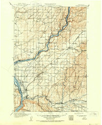
The confluence of the Snake River and Columbia River dominates this early 20th-century landscape, serving as a vital nexus for regional commerce and transit. Several major rail lines converge near the river junction, including the Northern Pacific Ry and the Oregon-Washington Railroad and Navigation Co, which navigate the steep bluffs through infrastructure like Tunnel No 9. The agricultural character of the era is evident in the numerous small educational houses scattered across the plateaus, such as Neff School and Wanser School, and the extensive Eureka Flat. Near the southern border, the Walla Walla River feeds into the Columbia, where the Wallula Ferry and settlements like Wallula and Two Rivers mark the historical transit points before modern bridge networks were fully established. Further inland, the irrigation-supported community of Gardena and the industrial activity near the Pumping Sta reflect the early development of the Walla Walla Valley.
Find a feature on this map
69 named features on this map. Tap any name to fly to it.
Don’t see what you’re looking for? This feature index may not catch every label — zoom into the map to look around manually.
Map Details
Editions of this 1918 Wallula Map
2 editions found
Other maps of this area

1908 · Umatilla
USGS Topo · 1:125,000

1915 · Wallulah
USGS Topo · 1:96,000

1916 · Connell
USGS Topo · 1:125,000

1917 · Pasco
USGS Topo · 1:125,000

1918 · Connell
USGS Topo · 1:125,000

1919 · Walla Walla
USGS Topo · 1:125,000

1921 · Walla Walla
USGS Topo · 1:125,000

1925 · Scooteney Lake
USGS Topo · 1:62,500

1935 · Pendleton
USGS Topo · 1:125,000

1948 · Ayer
USGS Topo · 1:62,500