1918 Map of Wallula
USGS Topo · Published 1951About this map
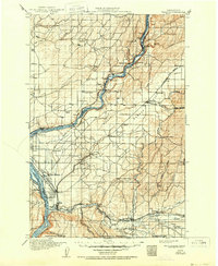
The confluence of the Columbia River and the Snake River anchors this 1915 survey of southeastern Washington, a landscape defined by its vital water-and-rail corridors. The community of Attalia and the transit hub of Wallula stand as primary junctions where the Union Pacific and Northern Pacific lines converge. To the east, the vast expanse of Eureka Flat is dotted with rural centers like Eureka and Adkins, while the southern reaches show the intricate irrigation and drainage of the Walla Walla River valley.
Find a feature on this map
81 named features on this map. Tap any name to fly to it.
Don’t see what you’re looking for? This feature index may not catch every label — zoom into the map to look around manually.
Map Details
Editions of this 1918 Wallula Map
2 editions found
Other maps of this area

1908 · Umatilla
USGS Topo · 1:125,000

1915 · Wallulah
USGS Topo · 1:96,000

1916 · Connell
USGS Topo · 1:125,000

1917 · Pasco
USGS Topo · 1:125,000

1918 · Connell
USGS Topo · 1:125,000

1918 · Wallula
USGS Topo · 1:125,000

1919 · Walla Walla
USGS Topo · 1:125,000

1921 · Walla Walla
USGS Topo · 1:125,000

1925 · Scooteney Lake
USGS Topo · 1:62,500

1935 · Pendleton
USGS Topo · 1:125,000