1964 Map of Wallula
USGS Topo · Published 1975About this map
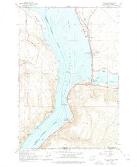
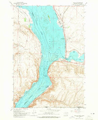
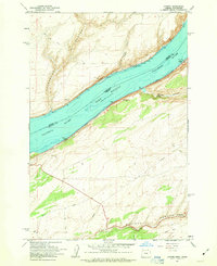
Wallula Lake dominates this mid-century landscape where the Columbia River forms a natural boundary between Benton and Walla Walla counties. The era’s industrial and transit infrastructure is clearly defined, featuring a paper mill near Attalia and the complex intersection of the Union Pacific and Spokane Portland and Seattle railroads. Significant historical landmarks are preserved on the sheet, including the Fort Walla Walla Historical Monument and the Madame Dorion Bridge crossing the Walla Walla River. The geography transitions from the elevations of the Horse Heaven Hills and Goose Gap down to the water’s edge, where Port Kelley stands as a vital shipping point. For researchers, the map provides precise locations for small settlements like Yellepit and various named features like the Two Sisters rock formations.
Find a feature on this map
33 named features on this map. Tap any name to fly to it.
Don’t see what you’re looking for? This feature index may not catch every label — zoom into the map to look around manually.
Map Details
Editions of this 1964 Wallula Map
2 editions found
Other maps of this area

1908 · Umatilla
USGS Topo · 1:125,000

1915 · Wallulah
USGS Topo · 1:96,000

1917 · Pasco
USGS Topo · 1:125,000

1918 · Wallula
USGS Topo · 1:125,000

1935 · Pendleton
USGS Topo · 1:125,000

1953 · Pendleton
USGS Topo · 1:250,000

1953 · Walla Walla
USGS Topo · 1:250,000

1956 · Pendleton
USGS Topo · 1:250,000

1958 · Walla Walla
USGS Topo · 1:250,000
1962 · Juniper
USGS Topo · 1:24,000