
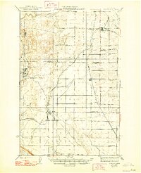
1924 Map of Othello
USGS Topo · Published 1924About this map
The high desert of central Washington is defined by its early 20th-century rail infrastructure and scattered agrarian outposts in this 1922 survey. Othello and Warden serve as the primary hubs, linked by the Chicago Milwaukee And ST Paul and Northern Pacific railroads. These lines were the lifelines of the region, facilitating the movement of goods across Paradise Flats and through the coulee-scarred landscape.
Find a feature on this map
26 named features on this map. Tap any name to fly to it.
Don’t see what you’re looking for? This feature index may not catch every label — zoom into the map to look around manually.
Map Details
Editions of this 1924 Othello Map
2 editions found
Other maps of this area

1912 · Moses Lake
USGS Topo · 1:62,500

1916 · Connell
USGS Topo · 1:125,000

1918 · Connell
USGS Topo · 1:125,000

1923 · Corfu
USGS Topo · 1:62,500

1923 · Wheeler
USGS Topo · 1:62,500

1924 · Hanford
USGS Topo · 1:62,500

1925 · Wheeler
USGS Topo · 1:62,500

1925 · Schrag
USGS Topo · 1:62,500

1925 · Scooteney Lake
USGS Topo · 1:62,500

1951 · Scooteney Lake
USGS Topo · 1:62,500