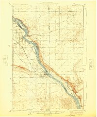
1924 Map of Hanford
USGS Topo · Published 1924About this map
The town of Hanford stands as the central hub of this 1920s survey, situated along the western bank of the Columbia River before the mid-century developments transformed the region. The landscape is defined by the river’s winding course and its named landforms, including Locke Island and Savage Island. Agricultural life is evident through a series of family-named settlements and outposts like Maplehurst Ranch, Wiehl Ranch, and Nagels Ranch, which pepper the river valley.
Find a feature on this map
28 named features on this map. Tap any name to fly to it.
Don’t see what you’re looking for? This feature index may not catch every label — zoom into the map to look around manually.
Map Details
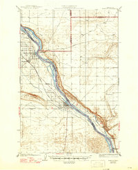
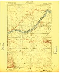
Editions of this 1924 Hanford Map
2 editions found
Other maps of this area

1911 · Red Rock
USGS Topo · 1:62,500

1915 · Prosser
USGS Topo · 1:125,000
1916 · Coyote Rapids
USGS Topo · 1:62,500

1917 · Pasco
USGS Topo · 1:125,000

1917 · Prosser
USGS Topo · 1:125,000

1923 · Corfu
USGS Topo · 1:62,500

1924 · Othello
USGS Topo · 1:62,500

1925 · Scooteney Lake
USGS Topo · 1:62,500

1950 · Smyrna
USGS Topo · 1:62,500

1951 · Scooteney Lake
USGS Topo · 1:62,500