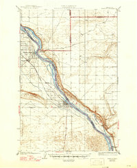
1924 Map of Hanford
USGS Topo · Published 1947About this map
Hanford and White Bluffs appear here as established agricultural river towns decades before the atomic era transformed this landscape. The Columbia River dominates the topography, winding past Locke Island and the steep East White Bluffs, while the Chicago Milwaukee and St Paul railroad tracks cut through the western flats. The presence of the Brick School and Ringold School suggests a dispersed but active ranching community, supported by irrigation via the Ditch near the Hanford townsite.
Find a feature on this map
30 named features on this map. Tap any name to fly to it.
Don’t see what you’re looking for? This feature index may not catch every label — zoom into the map to look around manually.
Map Details
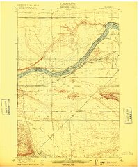
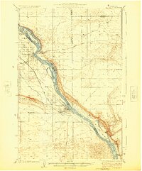
Editions of this 1924 Hanford Map
2 editions found
Other maps of this area

1911 · Red Rock
USGS Topo · 1:62,500

1915 · Prosser
USGS Topo · 1:125,000
1916 · Coyote Rapids
USGS Topo · 1:62,500

1917 · Pasco
USGS Topo · 1:125,000

1917 · Prosser
USGS Topo · 1:125,000

1923 · Corfu
USGS Topo · 1:62,500

1924 · Othello
USGS Topo · 1:62,500
1924 · Hanford
USGS Topo · 1:62,500

1925 · Scooteney Lake
USGS Topo · 1:62,500

1950 · Smyrna
USGS Topo · 1:62,500