1940s Maps of Grant County, Washington
Explore 3 historic maps of Grant County from the 1940s. These maps offer a rare glimpse into what life looked like during the 1940s — showing old roads, neighborhoods, homes, and landmarks that have changed or disappeared over time.
Whether you're researching your family's past, planning a metal detecting trip, or studying how Grant County's landscape evolved across the 1940s, these high-resolution maps are a powerful tool for exploring the history of this region.
- Focus on a specific era: All maps on this page are from the 1940s, giving you a focused view of this time period.
- See what’s changed: Compare century-old streets, trails, and buildings to today's modern landscape using overlays and satellite layers.
- Research with precision: Use these maps for genealogy, historical research, land use analysis, or educational projects.
- View, download, or print: Maps are fully viewable online in high resolution, and can be downloaded or printed for your own records.
Start exploring Grant County's history through authentic maps from the 1940s. This is your window into the past.
Grant County, WA maps
(3)- 1943 Map of Boylston
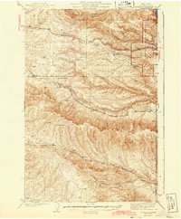 1943 Boylston1943 Print · USGSKittitas County is shown here during the early 1940s as a landscape of remote rail stops and geological wonders. Trace the path of the Milwaukee St Paul and Pacific through Boylston and find the early boundaries of Ginkgo Petrified Forest State Park.2 unique versions available
 - 1948 Map of Grand Coulee Dam, 1955 Print
 1948 Grand Coulee Dam1955 Print · USGSThe Grand Coulee region underwent a massive transformation by the late 1940s as the dam transformed the river valley into a sprawling reservoir. Trace the growth of Coulee Dam and Grand Coulee, and locate rural landmarks like the Grand Coulee Grange and Bagdad Junction.6 unique versions available
 - 1948 Map of Priest Rapids, 1958 Print
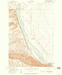 1948 Priest Rapids1958 Print · USGSThe Columbia River corridor is captured here in the late 1940s, split between the Yakima Firing Center Military Reservation and the Wahluke Slope. Researchers can trace the river's path through Priest Rapids, locating family sites like Stewart Ranch and the early Powerhouse.2 unique versions available
End of results
Showing maps 1-3 of 3
Top cities of Grant County
- Moses Lake historical maps
- Ephrata historical maps
- Quincy historical maps
- Mattawa historical maps
- Warden historical maps
- Royal City historical maps
See more
Frequently asked questions
- What are the different types of historical maps available for Grant County?
- What is the oldest map of Grant County?
- Where can I purchase historical maps of Grant County for my home or office?
- Where can I download high-res historical maps of Grant County?
- Are there historical topographic maps available for Grant County?
- Is there historical aerial imagery available for Grant County?
- Where are historical maps of Grant County sourced from?