
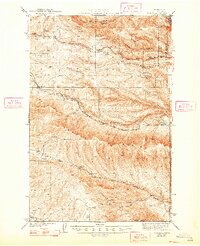
1943 Map of Boylston
USGS Topo · Published 1943About this map
Saddle Mountains dominate the southern landscape of this central Washington survey, providing a backdrop for a rugged territory defined by deep coulees and isolated springs. The Milwaukee St Paul and Pacific railroad cuts through the terrain, connecting the small settlements of Boylston and Doris. To the east, the Ginkgo Petrified Forest State Park preserves a unique geological history adjacent to the Columbia River corridor. The map reveals a land utilized for its scattered water sources, naming numerous points such as Whisky Dick Creek, Schnebly Coulee, and Lone Star Spr. This era captures the region's reliance on rail transport and its distinctive high-desert topography, with the Boylston Mtns and peaks like Holt Butte rising above the sagebrush-lined flats.
Find a feature on this map
26 named features on this map. Tap any name to fly to it.
Don’t see what you’re looking for? This feature index may not catch every label — zoom into the map to look around manually.
Map Details
Editions of this 1943 Boylston Map
2 editions found
Other maps of this area

1909 · Quincy
USGS Topo · 1:62,500

1910 · Quincy
USGS Topo · 1:62,500

1912 · Beverly
USGS Topo · 1:62,500

1917 · Priest Rapids
USGS Topo · 1:62,500

1920 · Colockum Pass
USGS Topo · 1:125,000

1922 · Colockum Pass
USGS Topo · 1:125,000

1936 · Yakima East
USGS Topo · 1:48,000

1936 · Hog Ranch Buttes
USGS Topo · 1:48,000

1938 · Badger Pocket
USGS Topo · 1:48,000

1939 · Boylston
USGS Topo · 1:48,000