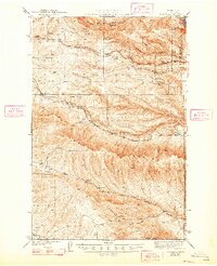
1943 Map of Boylston
USGS Topo · Published 1948About this map
The Chicago Milwaukee St Paul and Pacific railroad carves a winding path through this portion of Kittitas County, serving high-desert outposts like Boylston, Cheviot, and Doris. The landscape is defined by the massive uplift of the Saddle Mountains and the Boylston Mts, where numerous seasonal drainages such as Johnson Creek and Hanson Creek have etched deep coulees into the terrain. In the northeast corner, the preserve at Ginkgo Petrified Forest State Park protects unique geological specimens, while landmarks like Hole in the Wall and Hells Kitchen suggest a challenging, arid environment. Remote springs, including Poison Spr and Lone Star Spr, provide the only consistent water sources away from the primary creeks. The presence of Schnebly Road and several benchmarked summits indicates a surveyed wilderness transitioning toward the Columbia River corridor.
Find a feature on this map
30 named features on this map. Tap any name to fly to it.
Don’t see what you’re looking for? This feature index may not catch every label — zoom into the map to look around manually.
Map Details
Editions of this 1943 Boylston Map
2 editions found

Other maps of this area

1909 · Quincy
USGS Topo · 1:62,500

1910 · Quincy
USGS Topo · 1:62,500

1912 · Beverly
USGS Topo · 1:62,500

1917 · Priest Rapids
USGS Topo · 1:62,500

1920 · Colockum Pass
USGS Topo · 1:125,000

1922 · Colockum Pass
USGS Topo · 1:125,000

1936 · Yakima East
USGS Topo · 1:48,000

1936 · Hog Ranch Buttes
USGS Topo · 1:48,000

1938 · Badger Pocket
USGS Topo · 1:48,000

1939 · Boylston
USGS Topo · 1:48,000