
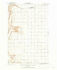
1939 Map of Boylston
USGS Topo · Published 1939About this map
The Milwaukee St Paul and Pacific railroad carves through the dramatic landscape of Kittitas County just before the onset of World War II, connecting the small settlements of Boylston and Doris. This arid high-country terrain is defined by the massive basalt folds of the Saddle Mountains and the Frenchman Hills, where seasonal water sources like Whisky Dick Creek and Poison Spr were critical landmarks for early travelers and stockmen.
Find a feature on this map
24 named features on this map. Tap any name to fly to it.
Don’t see what you’re looking for? This feature index may not catch every label — zoom into the map to look around manually.
Map Details
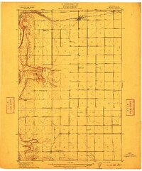
Editions of this 1939 Boylston Map
This is the sole edition of this map. No revisions or reprints were ever made.
Other maps of this area
1909 · Quincy
USGS Topo · 1:62,500
1910 · Quincy
USGS Topo · 1:62,500
1912 · Beverly
USGS Topo · 1:62,500

1917 · Priest Rapids
USGS Topo · 1:62,500

1920 · Colockum Pass
USGS Topo · 1:125,000

1922 · Colockum Pass
USGS Topo · 1:125,000

1936 · Yakima East
USGS Topo · 1:48,000

1936 · Hog Ranch Buttes
USGS Topo · 1:48,000

1938 · Badger Pocket
USGS Topo · 1:48,000
1941 · Black Rock Spring
USGS Topo · 1:62,500