Old Maps of Kittitas County, Washington
Explore 520 old maps of Kittitas County, spanning from 1897 to today. These high-resolution historic maps reveal how streets, neighborhoods, landmarks, and natural features evolved over time — perfect for genealogy, metal detecting, research, and local history exploration.
What you can do with these maps:
- See how Kittitas County changed over time: Compare historical maps to modern-day views to trace roads, homesites, rail lines & more.
- View detailed metadata: Each map includes creators, publishers, year, scale, and archive source.
- Overlay maps with satellite & LiDAR: Visualize the past alongside modern tools to explore terrain & human change.
- Trusted historical sources: Maps sourced from the USGS, Library of Congress, and other archives.
- Access maps your way: View online, download high-res files, or order prints for personal or research use.
Start exploring old maps of Kittitas County to uncover forgotten places, hidden landmarks, and the deep history beneath your feet.
Kittitas County, WA maps
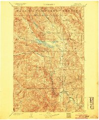
(520)- 1897 Map of Mount Stuart
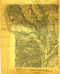
 1897 Mount Stuart1897 Print · USGSThe Kittitas Valley and Wenatchee Mountains are captured here at the end of the nineteenth century as coal and gold mining began to transform the frontier. Researchers can trace the early rail networks of the Northern Pacific and locate historic mining camps like Liberty, Meaghersville, and the remote Blewett station.2 unique versions available
 - 1899 Map of Ellensburg, 1957 Print
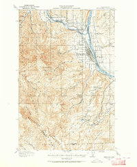
 1899 Ellensburg1957 Print · USGSCentral Washington at the turn of the century shows a landscape of growing river towns and high ridges. Researchers can trace early railroad expansion along the Northern Pacific RR or locate rural outposts like Tampico, Ahtanum, and Nile.
 - 1901 Map of Ellensburg
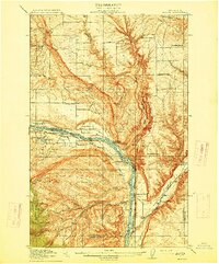
 1901 Ellensburg1901 Print · USGSCentral Washington at the turn of the century shows a landscape shaped by river valleys and high ridges. Trace the early Northern Pacific Railway line through Ellensburg and the remote outposts of Nile and Tampico.6 unique versions available
 - 1901 Map of Chiwaukum, 1956 Print
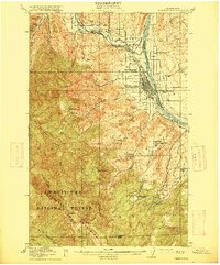
 1901 Chiwaukum1956 Print · USGSChelan County is captured at the dawn of the twentieth century as the railroad began to transform the high Cascades. Researchers can trace the original Great Northern R.R. route through mountain hamlets like Merritt, Winton, and the Dardanelles P O.2 unique versions available
 - 1901 Map of Snoqualmie Pass, 1956 Print
 1901 Snoqualmie Pass1956 Print · USGSSnoqualmie Pass and the central Cascades are seen here during the early years of transcontinental rail expansion. Trace the original Northern Pacific route through the Stampede Tunnel and past early mountain stops like Easton, Hyak, and Ronald.2 unique versions available
 - 1902 Map of Mount Aix
 1902 Mount Aix1902 Print · USGSThe eastern Cascades around Yakima are captured here at the start of the twentieth century, showing a high-country landscape of early mining and pack trails. Genealogists and historians can locate the site of Fife's Mine, the settlement at Goose Prairie, and early landmarks like Lake House.
 - 1902 Map of Skykomish
 1902 Skykomish1902 Print · USGSThe central Cascades were defined by the rail corridor at the turn of the century as the high passes were first conquered. Genealogists and historians can trace early mountain settlements like Monte Cristo, Mineral City, and Skykomish along the Great Northern Railway.
 - 1902 Map of Mount Stuart, 1908 Print
 1902 Mount Stuart1908 Print · USGSThe Kittitas Valley and Wenatchee Mountains are shown here during the height of the early twentieth-century rail and mining era. Researchers can trace the industrial landscape through the Roslyn Branch and mountain camps like Liberty and Blewett.5 unique versions available
 - 1903 Map of Snoqualmie
 1903 Snoqualmie1903 Print · USGSThe Cascade Range at the turn of the century was a landscape of high-altitude rail engineering and timber potential. Trace the Northern Pacific RR through the Stampede Tunnel to early mountain settlements like Easton and Lester.6 unique versions available
 - 1904 Map of Mt Aix
 1904 Mt Aix1904 Print · USGSThe high mountain passes and forest reserves of the Central Cascades are captured here at the start of the century. Genealogists and researchers can trace early outposts like Russell Ranch and the Lake House, or locate the Fires Mine and remote Mc Allister Meadows.6 unique versions available
 - 1904 Map of Chiwaukum
 1904 Chiwaukum1904 Print · USGSThe Great Northern corridor and the eastern slopes of the Cascades appear here just after the turn of the century. Trace the rail line through Leavenworth and Merritt, or locate remote landmarks like Soda Spring and Wenatchee Lake.6 unique versions available
 - 1905 Map of Skykomish
 1905 Skykomish1905 Print · USGSThe central Cascades at the start of the century reveal a landscape of high-altitude mining and the engineering of the Great Northern railroad. Trace early mountain settlements like Monte Cristo, the rail siding at Tonga, and the original Cascade Tunnel.7 unique versions available
 - 1909 Map of Quincy, 1965 Print
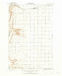 1909 Quincy1965 Print · USGSCentral Washington's high desert reveals its early rail and ranching roots just after the turn of the century. Trace the old rural schoolhouse network from Mountain View School to Glendale School and the growing town of Quincy along the Great Northern RR.
 - 1910 Map of Quincy
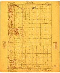 1910 Quincy1910 Print · USGSGrant County is captured in a moment of early expansion as homesteaders settled the basin during the first decade of the century. Genealogists can trace family roots through numerous rural landmarks like Evergreen School, Burke, and Haywood School.4 unique versions available
 - 1912 Map of Beverly
 1912 Beverly1912 Print · USGSCentral Washington is captured here at a pivotal moment just after the arrival of the railroad. You can trace the path of the Chicago Milwaukee and Puget Sound RR through riverfront settlements like Beverly and Cohassett.6 unique versions available
 - 1912 Map of Malaga
 1912 Malaga1912 Print · USGSCentral Washington's river-driven development is on display here just before the era of major hydroelectric projects. Genealogists and historians can trace an incredible density of early schools like Lower Stemilt School and settlements like Malaga and Vulcan.2 unique versions available
 - 1913 Map of Wenatchee, 1964 Print
 1913 Wenatchee1964 Print · USGSThe Wenatchee River valley and Columbia River shoreline thrived in the early 1910s as a burgeoning agricultural and rail hub. Genealogists can trace early homesteads and landmarks like Martins Ranch, the Great Northern Railway, and rural sites like Pitcher School.
 - 1914 Map of Malaga
 1914 Malaga1914 Print · USGSCentral Washington ranching and rail life are captured here just before World War I, centered on the Columbia River corridor. Genealogists and local historians can locate early homesteads and landmarks like the Sheehan Ranch, Malaga, and Liberty School.3 unique versions available
 - 1915 Map of Wenatchee
 1915 Wenatchee1915 Print · USGSWenatchee and the Columbia River valley are shown in the years before major dam construction, when the region's orchard economy was firmly established. Researchers can trace early railroad history along the Great Northern or locate rural landmarks like Mortins Ranch and Ferry School.3 unique versions available
 - 1917 Map of Priest Rapids
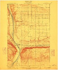
 1917 Priest Rapids1917 Print · USGSThe Columbia River bend and the high country of the Rattlesnake Hills are captured here during a period of early ranching and river industry. Genealogists and historians can locate remote outposts like Figure 2 Ranch, the site of Vernita, and the vital Richmond Ferry.2 unique versions available
 - 1920 Map of Colockum Pass
 1920 Colockum Pass1920 Print · USGSKittitas and Douglas counties are shown during a time of river ferries and mountain ranching. You can trace early schoolhouse locations like Whisky Dick School and follow the old Trinidad Ferry route across the Columbia River.
 - 1922 Map of Colockum Pass
 1922 Colockum Pass1922 Print · USGSEastern Washington ranching and river commerce are captured here just after the Great War, showing a landscape of high mountain passes and vital Columbia River crossings. Genealogists can trace family homesteads like Sheridan Ranch and local rural landmarks including Whisky Dick School and the Trinidad Ferry.2 unique versions available
 - 1936 Map of Yakima East
 1936 Yakima East1936 Print · USGSYakima and the Moxee Valley are shown here in the mid-1930s as the regional irrigation and rail networks were fully established. Genealogists and local historians can trace family locations near Pease Ranch, Moxee City, and schools like Central Sch.
 - 1936 Map of Hog Ranch Buttes
 1936 Hog Ranch Buttes1936 Print · USGSYakima and Kittitas counties are captured here in the mid-thirties, showing a vast ranching landscape defined by high ridges and deep canyons. Family historians can trace homesteads like Holmes Ranch and Meeboer Ranch, or locate local landmarks like Taylor Sch.
 - 1938 Map of Badger Pocket
 1938 Badger Pocket1938 Print · USGSThe Kittitas Valley at the end of the 1930s reveals a landscape of expanding irrigation and rail-connected settlements. Researchers can trace the extensive Cascade Canal system and locate family-history sites like Denmark Hall, Regal, and the Silica Mine.
Showing maps 1-25 of 520
Top cities of Kittitas County
- Kittitas historical maps
- Ellensburg historical maps
- Cle Elum historical maps
- Roslyn historical maps
- South Cle Elum historical maps
- Easton historical maps
See more
Frequently asked questions
- What are the different types of historical maps available for Kittitas County?
- What is the oldest map of Kittitas County?
- Where can I purchase historical maps of Kittitas County for my home or office?
- Where can I download high-res historical maps of Kittitas County?
- Are there historical topographic maps available for Kittitas County?
- Is there historical aerial imagery available for Kittitas County?
- Where are historical maps of Kittitas County sourced from?