1990s Maps of Kittitas County, Washington
Explore 3 historic maps of Kittitas County from the 1990s. These maps offer a rare glimpse into what life looked like during the 1990s — showing old roads, neighborhoods, homes, and landmarks that have changed or disappeared over time.
Whether you're researching your family's past, planning a metal detecting trip, or studying how Kittitas County's landscape evolved across the 1990s, these high-resolution maps are a powerful tool for exploring the history of this region.
- Focus on a specific era: All maps on this page are from the 1990s, giving you a focused view of this time period.
- See what’s changed: Compare century-old streets, trails, and buildings to today's modern landscape using overlays and satellite layers.
- Research with precision: Use these maps for genealogy, historical research, land use analysis, or educational projects.
- View, download, or print: Maps are fully viewable online in high resolution, and can be downloaded or printed for your own records.
Start exploring Kittitas County's history through authentic maps from the 1990s. This is your window into the past.
Kittitas County, WA maps
(3)- 1992 Map of Cliffdell, 1996 Print
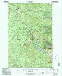 1992 Cliffdell1996 Print · USGSThe Naches River valley in the early nineties highlights a landscape of forest management and mountain recreation. Researchers can trace local landmarks like Peterson Cem and Camp Roganunda, or locate natural features such as Boulder Cave and Milk Pond.
 - 1992 Map of Manastash Lake, 1996 Print
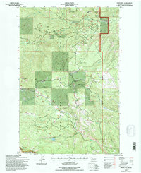
 1992 Manastash Lake1996 Print · USGSThe high Cascades at the Kittitas and Yakima county line appear here in the early 1990s, centered on the historic Naches Pass Trail. Researchers can trace old mountain routes through Canteen Flats and locate remote water sources like Manastash Lake and Cattle Camp Spring.
 - 1992 Map of Frost Mtn, 1996 Print
 1992 Frost Mtn1996 Print · USGSThe high ridges and timbered basins of Kittitas County are captured in the early nineties, centered on the Frost Mtn 6740 Lookout. Backcountry travelers and historians can trace the Taneum Ridge Trail or locate remote high-country spots like Manastash Lake and Keenan Meadows.
End of results
Showing maps 1-3 of 3
Top cities of Kittitas County
- Kittitas historical maps
- Ellensburg historical maps
- Cle Elum historical maps
- Roslyn historical maps
- South Cle Elum historical maps
- Easton historical maps
See more
Frequently asked questions
- What are the different types of historical maps available for Kittitas County?
- What is the oldest map of Kittitas County?
- Where can I purchase historical maps of Kittitas County for my home or office?
- Where can I download high-res historical maps of Kittitas County?
- Are there historical topographic maps available for Kittitas County?
- Is there historical aerial imagery available for Kittitas County?
- Where are historical maps of Kittitas County sourced from?