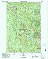
1992 Map of Cliffdell
USGS Topo · Published 1996About this map
The Naches River corridor serves as the primary artery for settlement and recreation through this mountain landscape, which was revised by the Forest Service in the early 1990s. This area, managed under the Mt Baker Snoqualmie National Forest, shows a clear concentration of human activity along the valley floor. Small clusters of development appear at Cliffdell and Pinecliff, while specialized sites such as Camp Roganunda and the Mountain Air Christian Camp Church illustrate the region's long-standing use for organized retreats and seasonal residence.
Find a feature on this map
25 named features on this map. Tap any name to fly to it.
Don’t see what you’re looking for? This feature index may not catch every label — zoom into the map to look around manually.
Map Details
Editions of this 1992 Cliffdell Map
This is the sole edition of this map. No revisions or reprints were ever made.
Other maps of this area

1897 · Mount Stuart
USGS Topo · 1:125,000

1899 · Ellensburg
USGS Topo · 1:125,000

1901 · Ellensburg
USGS Topo · 1:125,000

1901 · Snoqualmie Pass
USGS Topo · 1:125,000

1902 · Mount Aix
USGS Topo · 1:125,000

1902 · Mount Stuart
USGS Topo · 1:125,000

1903 · Snoqualmie
USGS Topo · 1:125,000

1904 · Mt Aix
USGS Topo · 1:125,000

1950 · Yakima
USGS Topo · 1:250,000

1957 · Wenatchee
USGS Topo · 1:250,000