
1936 Map of Yakima East
USGS Topo · Published 1936About this map
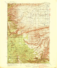
Yakima and the productive Moxee Valley are depicted here during a period of significant agricultural and infrastructure expansion. The valley floor is crisscrossed by an extensive network of local roads such as Morrier Lane and Birchfield Road, alongside the vital Irrigation Canal and Wapato Project works. This water management system supported the growing communities of Moxee City and Union Gap, which served as regional hubs for the surrounding farmstead landscape.
Find a feature on this map
52 named features on this map. Tap any name to fly to it.
Don’t see what you’re looking for? This feature index may not catch every label — zoom into the map to look around manually.
Map Details
Editions of this 1936 Yakima East Map
This is the sole edition of this map. No revisions or reprints were ever made.
Other maps of this area

1899 · Ellensburg
USGS Topo · 1:125,000

1901 · Ellensburg
USGS Topo · 1:125,000

1910 · Zillah
USGS Topo · 1:125,000

1936 · Hog Ranch Buttes
USGS Topo · 1:48,000
1937 · White Swan
USGS Topo · 1:125,000

1938 · Badger Pocket
USGS Topo · 1:48,000

1939 · Boylston
USGS Topo · 1:48,000
1941 · Black Rock Spring
USGS Topo · 1:62,500
1941 · Yakima East
USGS Topo · 1:62,500
1943 · Boylston
USGS Topo · 1:62,500