
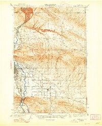
1941 Map of Yakima East
USGS Topo · Published 1941About this map
The Yakima River carves a critical corridor through the high ridges of central Washington, anchoring the region's early 20th-century agricultural and industrial expansion. The city of Yakima and nearby Union Gap serve as the hub for this valley, where the Northern Pacific and Union Pacific railroads meet. The landscape is defined by an intricate network of irrigation, including the Cascade Canal, Moxee Canal, and the Roza Canal, which transformed the arid flats between Yakima Ridge and the Rattlesnake Hills into productive farmland. Rural life is evidenced by family-named roads such as Postma Road and Beauchene Road, alongside community centers like the First Reformed Ch and Central School. To the south, the boundary of the Yakima Indian Reservation sits against the base of Ahtanum Ridge, marking a distinct shift in the valley's complex land-use history.
Find a feature on this map
49 named features on this map. Tap any name to fly to it.
Don’t see what you’re looking for? This feature index may not catch every label — zoom into the map to look around manually.
Map Details
Editions of this 1941 Yakima East Map
2 editions found
Other maps of this area

1899 · Ellensburg
USGS Topo · 1:125,000

1901 · Ellensburg
USGS Topo · 1:125,000

1910 · Zillah
USGS Topo · 1:125,000

1936 · Yakima East
USGS Topo · 1:48,000

1936 · Hog Ranch Buttes
USGS Topo · 1:48,000

1937 · White Swan
USGS Topo · 1:125,000

1938 · Badger Pocket
USGS Topo · 1:48,000

1939 · Boylston
USGS Topo · 1:48,000

1941 · Black Rock Spring
USGS Topo · 1:62,500

1943 · Boylston
USGS Topo · 1:62,500