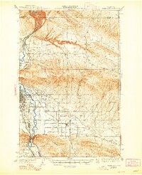
1941 Map of Yakima East
USGS Topo · Published 1948About this map
The Yakima River defines the western corridor of this 1930s landscape, serving as the lifeblood for a complex irrigation network that includes the Roza Canal and the Selam Irrigation Canal. This water infrastructure transformed the Moxee Valley into a productive agricultural hub, evidenced by the dense grid of rural roads named after local families, such as Beauchene Road, Postma Road, and Campbell Road. The urban center of Yakima is shown during a period of steady growth, featuring the State Fairgrounds and the Selah Country Club.
Find a feature on this map
47 named features on this map. Tap any name to fly to it.
Don’t see what you’re looking for? This feature index may not catch every label — zoom into the map to look around manually.
Map Details
Editions of this 1941 Yakima East Map
2 editions found
Other maps of this area

1899 · Ellensburg
USGS Topo · 1:125,000

1901 · Ellensburg
USGS Topo · 1:125,000

1910 · Zillah
USGS Topo · 1:125,000

1936 · Yakima East
USGS Topo · 1:48,000

1936 · Hog Ranch Buttes
USGS Topo · 1:48,000

1937 · White Swan
USGS Topo · 1:125,000

1938 · Badger Pocket
USGS Topo · 1:48,000

1939 · Boylston
USGS Topo · 1:48,000

1941 · Black Rock Spring
USGS Topo · 1:62,500

1941 · Yakima East
USGS Topo · 1:62,500