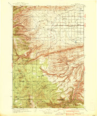
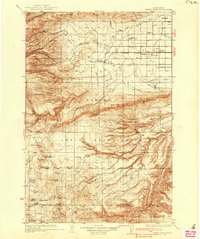
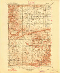
1937 Map of White Swan
USGS Topo · Published 1937About this map
The Yakima Indian Reservation dominates this 1930s landscape, illustrating a complex transition from high ridges to an engineered valley. The settlement of White Swan serves as a central hub, situated where the rugged slopes of Toppenish Ridge and Ahtanum Ridge give way to the agricultural developments of the Yakima Valley. This era is defined by the extensive irrigation network visible in the east, including the North Canal and Pump Canal, which supported towns like Harrah and Brownstown along the Northern Pacific railroad line.
Find a feature on this map
84 named features on this map. Tap any name to fly to it.
Don’t see what you’re looking for? This feature index may not catch every label — zoom into the map to look around manually.
Map Details
Editions of this 1937 White Swan Map
3 editions found
Other maps of this area

1899 · Ellensburg
USGS Topo · 1:125,000

1901 · Ellensburg
USGS Topo · 1:125,000

1902 · Mount Aix
USGS Topo · 1:125,000

1904 · Mt Aix
USGS Topo · 1:125,000

1904 · Mount Adams
USGS Topo · 1:125,000

1907 · Mount Adams
USGS Topo · 1:125,000

1910 · Zillah
USGS Topo · 1:125,000

1916 · Arlington
USGS Topo · 1:125,000

1934 · The Dalles
USGS Topo · 1:125,000

1936 · Yakima East
USGS Topo · 1:48,000