Old Maps of Klickitat County, Washington
Explore 222 old maps of Klickitat County, spanning from 1904 to today. These high-resolution historic maps reveal how streets, neighborhoods, landmarks, and natural features evolved over time — perfect for genealogy, metal detecting, research, and local history exploration.
What you can do with these maps:
- See how Klickitat County changed over time: Compare historical maps to modern-day views to trace roads, homesites, rail lines & more.
- View detailed metadata: Each map includes creators, publishers, year, scale, and archive source.
- Overlay maps with satellite & LiDAR: Visualize the past alongside modern tools to explore terrain & human change.
- Trusted historical sources: Maps sourced from the USGS, Library of Congress, and other archives.
- Access maps your way: View online, download high-res files, or order prints for personal or research use.
Start exploring old maps of Klickitat County to uncover forgotten places, hidden landmarks, and the deep history beneath your feet.
Klickitat County, WA maps
(222)- 1904 Map of Mount Adams, 1956 Print
 1904 Mount Adams1956 Print · USGSThe South Cascades and the Yakima Indian Reservation are captured here at the start of the twentieth century, during a time of early timber and ranching growth. Researchers can trace historic mills and stock routes through Glenwood, Hoppers Mill, and Parrotts Bridge.2 unique versions available
 - 1906 Map of Blalock Island, 1954 Print
 1906 Blalock Island1954 Print · USGSThe Columbia River corridor in the early twentieth century served as a vital nexus for Pacific Northwest rail and river trade. Researchers can trace the routes of three major railroads and locate early settlements and landmarks like Irrigon, Blalock Island, and Castle Rock.2 unique versions available
 - 1907 Map of Mount Adams
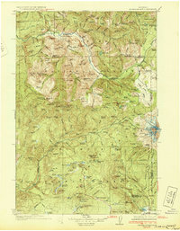
 1907 Mount Adams1907 Print · USGSThe high Cascades and the western reaches of the Yakima Reservation are mapped here in the early twentieth century. Researchers can locate early homesteads and industry like Kesslers Ranch, Lacroux Mill, and Glenwood among the glacial peaks.5 unique versions available
 - 1908 Map of Blalock Island
 1908 Blalock Island1908 Print · USGSThe Columbia River frontier of Oregon and Washington is captured here in the years before massive dam projects altered the basin. Researchers can trace the path of the Emigrant Road and locate early settlements like Douglas Morgan P.O., Cecil, and Irrigon.3 unique versions available
 - 1910 Map of Zillah
 1910 Zillah1910 Print · USGSThe Yakima River valley was transforming into an agricultural hub in the early 1900s as irrigation projects expanded. Researchers can trace the path of the Northern Pacific railroad through Toppenish and Wapato, or locate early sites like the Sawmill and Bluelight.3 unique versions available
 - 1915 Map of Prosser, 1957 Print
 1915 Prosser1957 Print · USGSThe Yakima Valley thrived as a rail and irrigation hub during the early twentieth century. Researchers can trace the layout of early schools and family-named homesteads like Orchard Ridge School, Snively Ranch, and the town of Prosser.
 - 1916 Map of Arlington
 1916 Arlington1916 Print · USGSThe Columbia River frontier of the mid-1910s reveals a world where the Oregon Trail and early railroads met the water. Genealogists can trace family roots through rural landmarks like Stegeman Ranch, Shutler, and the Locust Grove School.4 unique versions available
 - 1917 Map of Prosser
 1917 Prosser1917 Print · USGSBenton and Yakima counties thrive in the late teens as irrigation and rail lines transform the desert floor into a budding agricultural hub. Researchers can trace early family homesteads like Benson Ranch and numerous rural landmarks like Buena Vista School and the Gas Well.2 unique versions available
 - 1926 Map of Steamboat Mtn, 1954 Print
 1926 Steamboat Mtn1954 Print · USGSThe northern Cascades in the mid-twenties are shown here as a wilderness of timber and ice during the early years of the National Forest system. Researchers can locate remote outposts like Tower Rock Ranger Sta, the historic Williams Mine, and forgotten sites like Graveyard Camp.3 unique versions available
 - 1926 Map of Hood River, 1955 Print
 1926 Hood River1955 Print · USGSThe Columbia River Gorge in the mid-twenties shows a landscape defined by competing railroads and early trans-river engineering. Trace the rail lines between Stevenson and Hood River, or locate historic sites like Hemlock Sch and the Bridge of the Gods.
 - 1929 Map of Hood River
 1929 Hood River1929 Print · USGSThe Columbia River Gorge and Hood River Valley are captured here in the late twenties during a period of significant infrastructure growth. Researchers can trace the early rail networks, find remote forest outposts like Race Track Ranger Sta, and locate vanished landmarks such as the Government Sprs Hotel.3 unique versions available
 - 1931 Map of Steamboat Mtn
 1931 Steamboat Mtn1931 Print · USGSSkamania and Lewis Counties appear as a managed wilderness of national forests in the years before World War II. Researchers can trace the early footprint of forest management at the Cispus Lookout Sta and remote sites like Graveyard Camp or Buckhorn Camp.2 unique versions available
 - 1934 Map of The Dalles
 1934 The Dalles1934 Print · USGSThe Columbia River Gorge in the early thirties reveals a complex network of rapids and river engineering before the completion of major modern dams. Local historians can trace early school districts like Threemile Sch and family landmarks such as Clancy Ranch or Petersburg.4 unique versions available
 - 1937 Map of White Swan
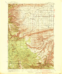 1937 White Swan1937 Print · USGSThe Yakima Indian Reservation in the mid-1930s reveals a landscape of high ridges meeting an emerging irrigation frontier. Genealogists and historians can trace early school sites like Medicine Valley Sch, the rail-stop at Harrah, and the historic grounds of Fort Simcoe.3 unique versions available
 - 1950 Map of Yakima, 1951 Print
 1950 Yakima1951 Print · USGSThe Yakima Valley and the towering Cascades meet in this mid-century survey of South Central Washington. Genealogists and local historians can trace the irrigation-era growth of Yakima, the historic Fort Simcoe outpost, and the White Swan Mission on the Yakima Indian Reservation.
 - 1953 Map of Pendleton, 1957 Print
 1953 Pendleton1957 Print · USGSNortheastern Oregon and the Columbia River frontier are captured here in the early fifties, a time of massive federal infrastructure projects. Researchers can trace the historic route of The Old Oregon Trail as it passes near the Umatilla Ordnance Depot and the new McNary Dam.4 unique versions available
 - 1953 Map of Walla Walla, 1964 Print
 1953 Walla Walla1964 Print · USGSSoutheast Washington enters the atomic and hydroelectric age in the mid-twentieth century as new dams reshape the desert landscape. You can trace the development of the Hanford Works, identify remote rail stops like Novara Siding, and locate the historic Dry Creek Cem.3 unique versions available
 - 1953 Map of The Dalles, 1965 Print
 1953 The Dalles1965 Print · USGSThe Columbia River Gorge at mid-century shows a region being transformed by massive hydroelectric dams and a growing highway network. Researchers can trace the development of The Dalles Dam, locate the Maryhill Museum, and find old rail stops in Rufus, Wishram, and Arlington.3 unique versions available
 - 1955 Map of Prosser SW, 1987 Print
 1955 Prosser SW1987 Print · USGSThe high plateau of South-Central Washington is captured in the mid-1960s, showing the intersection of Yakima and Klickitat counties. Researchers can trace early family-named routes like Poeckes Road and Wandling Road leading toward the landmark at Plainview.
 - 1956 Map of The Dalles
 1956 The Dalles1956 Print · USGSThe Columbia River Gorge and the high Cascades are captured in the mid-1950s, showing a vital corridor of rail and road. Researchers can trace the original path of The Old Oregon Trail or locate historical landmarks like the Maryhill Museum and Mount Hood.
 - 1956 Map of Pendleton
 1956 Pendleton1956 Print · USGSNortheastern Oregon’s high plateau and timbered peaks appear here in the mid-fifties, during a time of major military and hydroelectric development. Trace the path of The Old Oregon Trail alongside modern landmarks like McNary Dam and the Umatilla Ordnance Depot.
 - 1957 Map of The Dalles
 1957 The Dalles1957 Print · USGSThe Columbia River Gorge and the high plateaus of the mid-1950s come alive on this detailed survey of northern Oregon and southern Washington. Researchers can trace the path of the Oregon Trail and The Old Barlow Road alongside river towns like The Dalles and Wishram.
 - 1957 Map of Wasco, 1959 Print
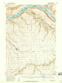 1957 Wasco1959 Print · USGSSherman County and the Columbia River frontier are captured in the late fifties, showing the vital rail and water routes of the Inland Empire. Researchers can trace historic settlements from Wasco to Klondike and locate family landmarks like Sunrise Cemetery.2 unique versions available
 - 1957 Map of Klickitat, 1959 Print
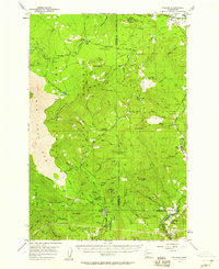
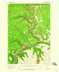 1957 Klickitat1959 Print · USGSThe river canyon around Klickitat was a busy corridor of timber and rail activity in the 1950s. Researchers can locate specialized sites like Woodruff Mill, the tiny settlement of Wahiacus, and the historic Spokane Portland and Seattle Railroad line.2 unique versions available
 - 1957 Map of Willard, 1959 Print
 1957 Willard1959 Print · USGSSkamania and Klickitat Counties are shown here during the late 1950s, highlighting the active timber and forest management culture of the Gifford Pinchot National Forest. Researchers can trace historic industrial sites like Mill A and Mill B or locate remote landmarks such as the Peterson Guard Sta and Ice Caves.3 unique versions available
Showing maps 1-25 of 222
Top cities of Klickitat County
- Goldendale historical maps
- White Salmon historical maps
- Bingen historical maps
- Bickleton historical maps
Frequently asked questions
- What are the different types of historical maps available for Klickitat County?
- What is the oldest map of Klickitat County?
- Where can I purchase historical maps of Klickitat County for my home or office?
- Where can I download high-res historical maps of Klickitat County?
- Are there historical topographic maps available for Klickitat County?
- Is there historical aerial imagery available for Klickitat County?
- Where are historical maps of Klickitat County sourced from?