1950s Maps of Klickitat County, Washington
Explore 20 historic maps of Klickitat County from the 1950s. These maps offer a rare glimpse into what life looked like during the 1950s — showing old roads, neighborhoods, homes, and landmarks that have changed or disappeared over time.
Whether you're researching your family's past, planning a metal detecting trip, or studying how Klickitat County's landscape evolved across the 1950s, these high-resolution maps are a powerful tool for exploring the history of this region.
- Focus on a specific era: All maps on this page are from the 1950s, giving you a focused view of this time period.
- See what’s changed: Compare century-old streets, trails, and buildings to today's modern landscape using overlays and satellite layers.
- Research with precision: Use these maps for genealogy, historical research, land use analysis, or educational projects.
- View, download, or print: Maps are fully viewable online in high resolution, and can be downloaded or printed for your own records.
Start exploring Klickitat County's history through authentic maps from the 1950s. This is your window into the past.
Klickitat County, WA maps
(20)- 1950 Map of Yakima, 1951 Print
 1950 Yakima1951 Print · USGSThe Yakima Valley and the towering Cascades meet in this mid-century survey of South Central Washington. Genealogists and local historians can trace the irrigation-era growth of Yakima, the historic Fort Simcoe outpost, and the White Swan Mission on the Yakima Indian Reservation.
 - 1953 Map of Pendleton, 1957 Print
 1953 Pendleton1957 Print · USGSNortheastern Oregon and the Columbia River frontier are captured here in the early fifties, a time of massive federal infrastructure projects. Researchers can trace the historic route of The Old Oregon Trail as it passes near the Umatilla Ordnance Depot and the new McNary Dam.4 unique versions available
 - 1953 Map of Walla Walla, 1964 Print
 1953 Walla Walla1964 Print · USGSSoutheast Washington enters the atomic and hydroelectric age in the mid-twentieth century as new dams reshape the desert landscape. You can trace the development of the Hanford Works, identify remote rail stops like Novara Siding, and locate the historic Dry Creek Cem.3 unique versions available
 - 1953 Map of The Dalles, 1965 Print
 1953 The Dalles1965 Print · USGSThe Columbia River Gorge at mid-century shows a region being transformed by massive hydroelectric dams and a growing highway network. Researchers can trace the development of The Dalles Dam, locate the Maryhill Museum, and find old rail stops in Rufus, Wishram, and Arlington.3 unique versions available
 - 1955 Map of Prosser SW, 1987 Print
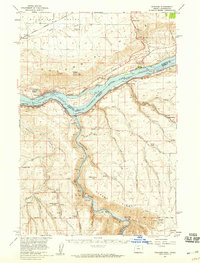
 1955 Prosser SW1987 Print · USGSThe high plateau of South-Central Washington is captured in the mid-1960s, showing the intersection of Yakima and Klickitat counties. Researchers can trace early family-named routes like Poeckes Road and Wandling Road leading toward the landmark at Plainview.
 - 1956 Map of The Dalles
 1956 The Dalles1956 Print · USGSThe Columbia River Gorge and the high Cascades are captured in the mid-1950s, showing a vital corridor of rail and road. Researchers can trace the original path of The Old Oregon Trail or locate historical landmarks like the Maryhill Museum and Mount Hood.
 - 1956 Map of Pendleton
 1956 Pendleton1956 Print · USGSNortheastern Oregon’s high plateau and timbered peaks appear here in the mid-fifties, during a time of major military and hydroelectric development. Trace the path of The Old Oregon Trail alongside modern landmarks like McNary Dam and the Umatilla Ordnance Depot.
 - 1957 Map of The Dalles
 1957 The Dalles1957 Print · USGSThe Columbia River Gorge and the high plateaus of the mid-1950s come alive on this detailed survey of northern Oregon and southern Washington. Researchers can trace the path of the Oregon Trail and The Old Barlow Road alongside river towns like The Dalles and Wishram.
 - 1957 Map of Wasco, 1959 Print
 1957 Wasco1959 Print · USGSSherman County and the Columbia River frontier are captured in the late fifties, showing the vital rail and water routes of the Inland Empire. Researchers can trace historic settlements from Wasco to Klondike and locate family landmarks like Sunrise Cemetery.2 unique versions available
 - 1957 Map of Klickitat, 1959 Print
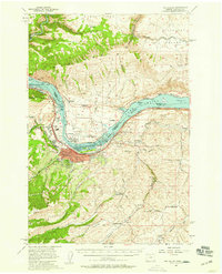
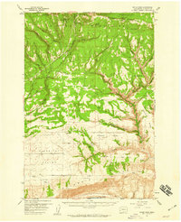
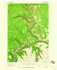 1957 Klickitat1959 Print · USGSThe river canyon around Klickitat was a busy corridor of timber and rail activity in the 1950s. Researchers can locate specialized sites like Woodruff Mill, the tiny settlement of Wahiacus, and the historic Spokane Portland and Seattle Railroad line.2 unique versions available
 - 1957 Map of Willard, 1959 Print
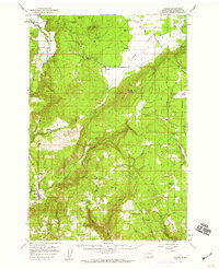
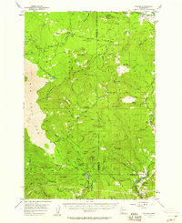 1957 Willard1959 Print · USGSSkamania and Klickitat Counties are shown here during the late 1950s, highlighting the active timber and forest management culture of the Gifford Pinchot National Forest. Researchers can trace historic industrial sites like Mill A and Mill B or locate remote landmarks such as the Peterson Guard Sta and Ice Caves.3 unique versions available
 - 1957 Map of Goldendale, 1959 Print
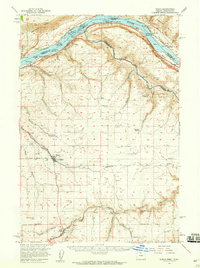
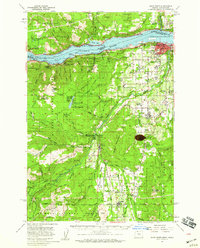
 1957 Goldendale1959 Print · USGSMid-century Klickitat County comes alive in this survey of the Goldendale area during its post-war growth. Genealogists and historians can trace local landmarks like Orchard Heights School, the A J Bolon Historic Monument, and the rural settlement of Blockhouse.2 unique versions available
 - 1957 Map of The Dalles, 1959 Print
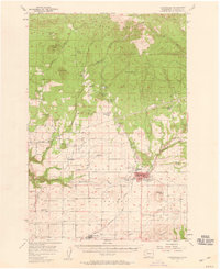
 1957 The Dalles1959 Print · USGSThe Dalles and the Columbia River frontier are captured here in the late fifties, just as the new dam transformed the river. Genealogists can locate family schools like Fairfield Sch and Chenoweth School or trace the early footprint of Dallesport.3 unique versions available
 - 1957 Map of Wishram, 1959 Print
 1957 Wishram1959 Print · USGSThe Columbia Gorge in the late fifties was a powerhouse of rail transport and river management. Trace the junction of the S P & S and Union Pacific railroads near Wishram, and find rural landmarks like the Stonehenge Memorial and Douglas Hollow School.2 unique versions available
 - 1957 Map of White Salmon, 1959 Print
 1957 White Salmon1959 Print · USGSThe Columbia River Gorge in the late fifties shows a bustling corridor of rail and river transport. Researchers can locate family landmarks like Ketchum Ranch, old meeting halls such as Mill Creek Grange, and the riverfront communities of Bingen and Mosier.2 unique versions available
 - 1957 Map of Husum, 1959 Print
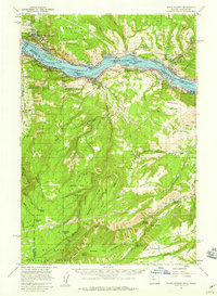
 1957 Husum1959 Print · USGSMid-century Klickitat County comes into focus here, showing the rural communities and timber-related geography before modern development. Genealogists and researchers can trace family lands near Husum, Snowden, and the Mt Adams Cemetery.3 unique versions available
 - 1957 Map of Satus Pass, 1959 Print
 1957 Satus Pass1959 Print · USGSThe Klickitat Valley in the late fifties is a landscape of mountain passes and high prairie settlements. Genealogists and local historians can trace family locations near the Pleasant Valley Cemetery, the Grange Hall, and the mountain crossroads of Bickleton.3 unique versions available
 - 1957 Map of Hood River, 1959 Print
 1957 Hood River1959 Print · USGSThe Columbia River Gorge in the late fifties is captured here as a thriving corridor of rail, timber, and orchard life. Genealogists and historians can trace local landmarks like Pine Grove Cem, the community at Odell, and early forest service sites such as Kingsley Guard Sta.3 unique versions available
 - 1958 Map of Walla Walla
 1958 Walla Walla1958 Print · USGSThe Tri-Cities and Walla Walla region are captured here during the mid-century expansion of atomic energy and river infrastructure. Genealogists and historians can trace the early layout of Richland (AEC), the rural Hatton and Washtucna settlements, and landmarks like Palouse Falls State Park.
 - 1958 Map of Yakima, 1964 Print
 1958 Yakima1964 Print · USGSThe Yakima Valley in the late fifties shows a landscape of mountain peaks and irrigated plains at the height of its rail-era development. Researchers can trace the lineage of early settlements through sites like Fort Simcoe, the Wenas Cemetery, and the Yakima Indian Agency School.3 unique versions available
End of results
Showing maps 1-20 of 20
Top cities of Klickitat County
- Goldendale historical maps
- White Salmon historical maps
- Bingen historical maps
- Bickleton historical maps
Frequently asked questions
- What are the different types of historical maps available for Klickitat County?
- What is the oldest map of Klickitat County?
- Where can I purchase historical maps of Klickitat County for my home or office?
- Where can I download high-res historical maps of Klickitat County?
- Are there historical topographic maps available for Klickitat County?
- Is there historical aerial imagery available for Klickitat County?
- Where are historical maps of Klickitat County sourced from?