2020s Maps of Grant County, Washington
Explore 78 historic maps of Grant County from the 2020s. These maps offer a rare glimpse into what life looked like during the 2020s — showing old roads, neighborhoods, homes, and landmarks that have changed or disappeared over time.
Whether you're researching your family's past, planning a metal detecting trip, or studying how Grant County's landscape evolved across the 2020s, these high-resolution maps are a powerful tool for exploring the history of this region.
- Focus on a specific era: All maps on this page are from the 2020s, giving you a focused view of this time period.
- See what’s changed: Compare century-old streets, trails, and buildings to today's modern landscape using overlays and satellite layers.
- Research with precision: Use these maps for genealogy, historical research, land use analysis, or educational projects.
- View, download, or print: Maps are fully viewable online in high resolution, and can be downloaded or printed for your own records.
Start exploring Grant County's history through authentic maps from the 2020s. This is your window into the past.
Grant County, WA maps
(78)- 2023 Map of Beverly NE, 2023 Print
 2023 Beverly NE2023 Print · USGSThe high-desert terrain of Grant County is defined by mid-century irrigation projects and the rising Frenchman Hills. Trace the complex water network of the West Canal and the Royal Branch Canal as they transform the Royal Slope.
 - 2023 Map of Priest Rapids, 2023 Print
 2023 Priest Rapids2023 Print · USGSThe Columbia River corridor south of the Saddle Mountains shows a landscape of modern irrigation and aviation in the early twenty-first century. Researchers can trace the development of Mattawa and Desert Aire, alongside the terrain of Umtanum Ridge and Goose Island.
 - 2023 Map of Royal Camp, 2023 Print
 2023 Royal Camp2023 Print · USGSCentral Grant County is defined here by the managed waters of the Columbia Basin Project and the rising ridge of the Frenchman Hills. Genealogists and local researchers can locate Pleasant Valley Cem or trace irrigation routes like West Canal and Crab Creek Lateral.
 - 2023 Map of Vernita Bridge, 2023 Print
 2023 Vernita Bridge2023 Print · USGSThe Columbia River desert of the early twenty-first century is defined by its massive federal conservation and historical sites. Researchers can trace the borders of the Manhattan Project National Historical Park and the Saddle Mountain National Wildlife Refuge.
 - 2023 Map of Warden, 2023 Print
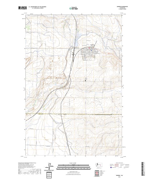 2023 Warden2023 Print · USGSThe irrigation-driven settlement of central Washington is on full display here, showing the growth of Warden alongside the East Low Canal. Local historians can trace the Palouse To Cascades State Park Trl and find family landmarks like Sunset Memorial Gardens.
 - 2023 Map of Hanford NE, 2023 Print
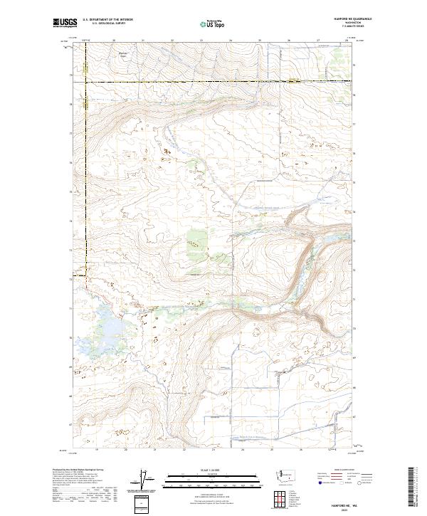 2023 Hanford NE2023 Print · USGSFranklin and Grant counties appear as a landscape of conservation and large-scale irrigation in the early 2020s. Researchers can trace the path of the Wahluke Branch Canal or explore the boundaries of the Hanford Reach National Monument.
 - 2023 Map of Locke Island, 2023 Print
 2023 Locke Island2023 Print · USGSThe Columbia River flows through a landscape of profound scientific and natural history in the modern day. Researchers can trace the intersection of the Manhattan Project National Historical Park and protected lands like Locke Island and the White Bluffs.
 - 2023 Map of Priest Rapids NE, 2023 Print
 2023 Priest Rapids NE2023 Print · USGSThe Columbia River basin and the southern edges of Grant County are shown here in modern detail. Trace the landscape from the Wahluke Slope to the river's edge, including the Saddle Mountain National Wildlife Refuge and China Bar.
 - 2023 Map of Beverly, 2023 Print
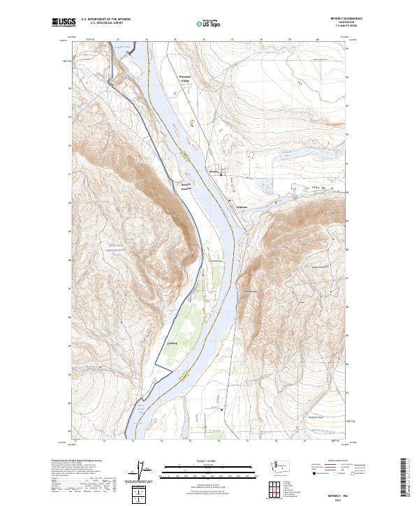 2023 Beverly2023 Print · USGSThe Columbia River corridor is captured here in the early twenty-first century, showing the intersection of hydro-infrastructure and natural preserves. Researchers can trace the river from Wanapum Lake through Sentinel Gap past settlements like Beverly and Schwana.
 - 2023 Map of Frenchman Hills Lake, 2023 Print
 2023 Frenchman Hills Lake2023 Print · USGSRoyal City and the productive orchards of the Royal Slope are shown in great detail during the early 2020s. Researchers can trace the essential irrigation networks of the West Canal and Crab Creek Lateral alongside local landmarks like Christensen Field.
 - 2023 Map of Royal City, 2023 Print
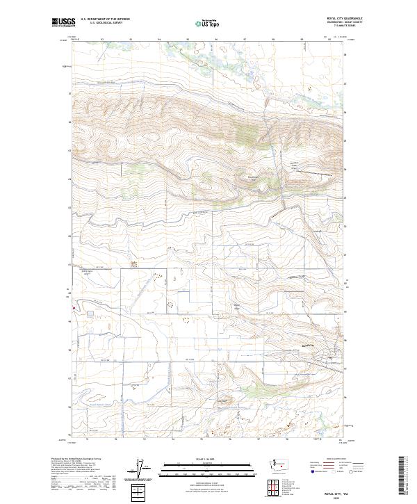 2023 Royal City2023 Print · USGSRoyal City and the surrounding Columbia Basin landscape are captured here in the early 2020s, showing the intricate water and road systems of this agricultural region. Researchers can trace the massive irrigation network through the Royal Branch Canal or locate local landmarks like Cash Butte and the Stillwater Creek Airport.
 - 2023 Map of Soda Lake, 2023 Print
 2023 Soda Lake2023 Print · USGSThe central Washington basin south of the Potholes Reservoir is defined by its dramatic coulee wetlands and conservation lands in this recent survey. Local historians and outdoor enthusiasts can trace the paths of Lower Crab Creek Trl and identify dozens of remote water bodies like Hampton Lake and Deadman Lake.
 - 2023 Map of Coyote Rapids, 2023 Print
 2023 Coyote Rapids2023 Print · USGSThe Columbia River corridor south of the Saddle Mountains appears here as a landscape shaped by massive federal projects and conservation. Historians can trace the boundaries of the Manhattan Project National Historical Park and locate small named places like Wahluke, Bettie, and Nancy.
 - 2023 Map of Smyrna, 2023 Print
 2023 Smyrna2023 Print · USGSThe northern edge of the Saddle Mountains meets the irrigated fields of Grant County in this recent survey. Trace the path of Lower Crab Creek through the Columbia National Wildlife Refuge and the high vistas of Smyrna Bench.
 - 2023 Map of Wheeler NE, 2023 Print
 2023 Wheeler NE2023 Print · USGSGrant County agriculture and coulee terrain are captured here in the early twenty-first century. Genealogists and local historians can trace the settlement at Ruff, find the Schultz Memorial Cem, and follow the deep paths of Rocky Coulee.
 - 2023 Map of Winchester, 2023 Print
 2023 Winchester2023 Print · USGSThe settlement of Winchester sits amidst a modern agricultural grid defined by the Frenchman Hills in the twenty-first century. Researchers can trace the path of vital irrigation infrastructure like the Winchester Wasteway and Frenchman Hills Wasteway.
 - 2023 Map of Sims Corner, 2023 Print
 2023 Sims Corner2023 Print · USGSDouglas County’s high plateau is captured here in the early twenty-first century, showing a landscape of geometric farm roads and isolated basins. Genealogists and local historians can trace the rural routes around Sims Corner or locate the quiet waters of Horse Lake.
 - 2023 Map of Marlin SW, 2023 Print
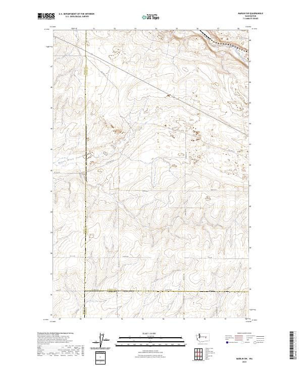 2023 Marlin SW2023 Print · USGSThe high scabland plateaus at the meeting point of Grant, Lincoln, and Adams counties are captured here in the modern era. Researchers can trace the rugged drainage of Black Rock Coulee and locate remote rural landmarks like Old Hwy Lp and Kissler Rd.
 - 2023 Map of Evergreen Ridge, 2023 Print
 2023 Evergreen Ridge2023 Print · USGSCentral Washington’s dramatic geography is captured here in the early twenty-first century, featuring the deep incision of Frenchman Coulee. Researchers can trace the legacy of regional water management through Evergreen Reservoir and the historic route of the Old Vantage Hwy.
 - 2023 Map of Barker Canyon, 2023 Print
 2023 Barker Canyon2023 Print · USGSThe high desert of Douglas and Grant Counties is captured in this contemporary survey of the Channeled Scablands. Local historians and geologists can trace the dramatic landscape from Banks Lake up through the sheer walls of Barker Canyon to Steamboat Butte.
 - 2023 Map of Bassett Junction, 2023 Print
 2023 Bassett Junction2023 Print · USGSGrant County agricultural lands and water management systems come into focus in this recent survey. Local historians can trace the paths of East Low Canal and Weber Wasteway near small settlements like Bassett Junction, Tiflis, and Barham.
 - 2023 Map of Moses Lake NW, 2023 Print
 2023 Moses Lake NW2023 Print · USGSThe Grant County shoreline and its agricultural hinterlands come into focus in this contemporary survey. Genealogists and local historians can trace family locations near Mae Valley, the waters of Moses Lake, and the winding path of Rocky Ford Creek.
 - 2023 Map of Wilson Creek SW, 2023 Print
 2023 Wilson Creek SW2023 Print · USGSGrant County is shown here in its modern agricultural and desert state, defined by significant water management projects. Researchers can trace the path of the East Low Canal and locate remote landmarks like Black Lake and Black Rock Coulee.
 - 2023 Map of Monument Hill, 2023 Print
 2023 Monument Hill2023 Print · USGSQuincy and the surrounding basalt ridges are captured in this modern survey of central Washington's agricultural frontier. Researchers can trace the path of the Quincy Lateral Canal and the climb toward landmarks like Monument Hill and the Beezley Hills.
 - 2023 Map of Mae, 2023 Print
 2023 Mae2023 Print · USGSGrant County’s agricultural heartland and massive water projects are on display in this contemporary survey of the Mae area. Genealogists and local researchers can trace family lands near Mae Valley and the shoreline of the Potholes Reservoir.
Showing maps 1-25 of 78
Top cities of Grant County
- Moses Lake historical maps
- Ephrata historical maps
- Quincy historical maps
- Mattawa historical maps
- Warden historical maps
- Royal City historical maps
See more
Frequently asked questions
- What are the different types of historical maps available for Grant County?
- What is the oldest map of Grant County?
- Where can I purchase historical maps of Grant County for my home or office?
- Where can I download high-res historical maps of Grant County?
- Are there historical topographic maps available for Grant County?
- Is there historical aerial imagery available for Grant County?
- Where are historical maps of Grant County sourced from?