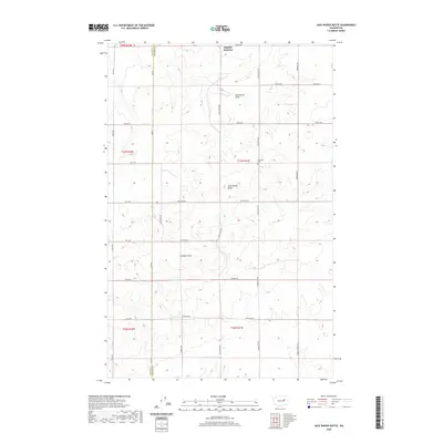
2020 Map of Jack Woods Butte
USGS Topo · Published 2020About this map
Jack Woods Butte rises from the high plains of the eastern Washington landscape at the boundary of Grant and Lincoln Counties. This area is characterized by a network of drainage features such as Klobuschar Draw and Childers Draw, which illustrate the complex water patterns that shaped this territory. The small settlement of Bagdad Junction sits at the northern edge, serving as a focal point for a rural road system that includes Old Coulee Rd and Lafollette Rd. For genealogists and local historians, the Lafollette Cem is a significant landmark located near the center of the sheet, while family-named routes like Starkel Rd and Sorensen Rd indicate the area's agricultural history. The intermittent flow of Devils Cr further highlights the arid nature of this plateau region during the early twenty-first century.
Find a feature on this map
35 named features on this map. Tap any name to fly to it.
Don’t see what you’re looking for? This feature index may not catch every label — zoom into the map to look around manually.
Map Details
Editions of this 2020 Jack Woods Butte Map
This is the sole edition of this map. No revisions or reprints were ever made.
Other maps of this area

1948 · Grand Coulee Dam
USGS Topo · 1:62,500

1950 · Grand Coulee Dam
USGS Topo · 1:62,500

1953 · Ritzville
USGS Topo · 1:250,000

1959 · Ritzville
USGS Topo · 1:250,000

1965 · Ritzville
USGS Topo · 1:250,000

1968 · Hartline
USGS Topo · 1:24,000

1968 · Steamboat Rock SE
USGS Topo · 1:24,000
1968 · Electric City
USGS Topo · 1:24,000

1969 · Almira
USGS Topo · 1:24,000

1969 · Govan
USGS Topo · 1:24,000