
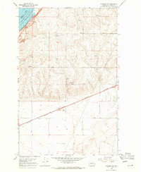
1968 Map of Hartline
USGS Topo · Published 1971About this map
Hartline is the central hub of this agricultural landscape in the late 1960s, defined by the Burlington Northern railroad corridor. The town’s role as a shipping point for the surrounding wheat country is evident in the Grain Elevators positioned along the tracks, while the secondary settlement of Hanson sits to the northeast. The terrain is structured by a precise grid of county roads, from Road 45 NE down to Road 37 NE, which navigate the subtle coulees and natural springs that dot the region.
Find a feature on this map
21 named features on this map. Tap any name to fly to it.
Don’t see what you’re looking for? This feature index may not catch every label — zoom into the map to look around manually.
Map Details
Editions of this 1968 Hartline Map
This is the sole edition of this map. No revisions or reprints were ever made.
Other maps of this area

1948 · Grand Coulee Dam
USGS Topo · 1:62,500

1950 · Grand Coulee Dam
USGS Topo · 1:62,500

1953 · Ritzville
USGS Topo · 1:250,000

1959 · Ritzville
USGS Topo · 1:250,000

1965 · Ritzville
USGS Topo · 1:250,000

1968 · Steamboat Rock SW
USGS Topo · 1:24,000

1968 · Hartline SW
USGS Topo · 1:24,000

1968 · Steamboat Rock SE
USGS Topo · 1:24,000

1968 · Hartline SE
USGS Topo · 1:24,000
1968 · Hartline NW
USGS Topo · 1:24,000