
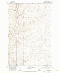
1969 Map of Govan
USGS Topo · Published 1972About this map
Govan serves as the primary hub of this landscape at the end of the 1960s, defined by the Burlington Northern railroad corridor and the massive Grain Elevators that anchor the settlement. This is the heart of Big Bend country, where the coulee-carved terrain creates a complex drainage system of intermittent streams and isolated potholes. The map reveals a land structured by water access, with family-named or descriptively titled features like Jarchow Lake, Rattlesnake Lake, and Fiddle Box Spring scattered among the draws.
Find a feature on this map
20 named features on this map. Tap any name to fly to it.
Don’t see what you’re looking for? This feature index may not catch every label — zoom into the map to look around manually.
Map Details
Editions of this 1969 Govan Map
This is the sole edition of this map. No revisions or reprints were ever made.
Other maps of this area

1948 · Grand Coulee Dam
USGS Topo · 1:62,500

1948 · Wilbur
USGS Topo · 1:62,500

1950 · Wilbur
USGS Topo · 1:62,500

1950 · Grand Coulee Dam
USGS Topo · 1:62,500

1953 · Ritzville
USGS Topo · 1:250,000

1959 · Ritzville
USGS Topo · 1:250,000

1965 · Ritzville
USGS Topo · 1:250,000

1969 · Almira
USGS Topo · 1:24,000

1969 · Almira SE
USGS Topo · 1:24,000
1969 · Almira SW
USGS Topo · 1:24,000