Old Maps of Lincoln County, Washington
Explore 364 old maps of Lincoln County, spanning from 1944 to today. These high-resolution historic maps reveal how streets, neighborhoods, landmarks, and natural features evolved over time — perfect for genealogy, metal detecting, research, and local history exploration.
What you can do with these maps:
- See how Lincoln County changed over time: Compare historical maps to modern-day views to trace roads, homesites, rail lines & more.
- View detailed metadata: Each map includes creators, publishers, year, scale, and archive source.
- Overlay maps with satellite & LiDAR: Visualize the past alongside modern tools to explore terrain & human change.
- Trusted historical sources: Maps sourced from the USGS, Library of Congress, and other archives.
- Access maps your way: View online, download high-res files, or order prints for personal or research use.
Start exploring old maps of Lincoln County to uncover forgotten places, hidden landmarks, and the deep history beneath your feet.
Lincoln County, WA maps
(364)- 1944 Map of Wellpinit
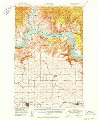
 1944 Wellpinit1944 Print · USGSThe Spokane Indian Reservation and the winding Spokane River define this 1940s landscape during an era of logging and early hydroelectric power. Genealogists and historians can trace the foundations of local life at Wellpinit, the Deer Park Logging Camp, and the State Fish Hatchery.2 unique versions available
 - 1945 Map of Reardan
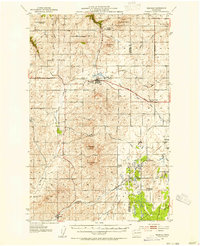
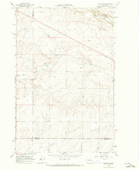
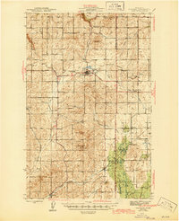 1945 Reardan1945 Print · USGSThe Lincoln County plateau in the mid-forties was a vital crossroads of the Great Northern and Northern Pacific railroads. Genealogists can locate family landmarks like District School No 1, Pleasant View Cem, and the high point of Hanning Butte.2 unique versions available
 - 1948 Map of Grand Coulee Dam, 1955 Print
 1948 Grand Coulee Dam1955 Print · USGSThe Grand Coulee region underwent a massive transformation by the late 1940s as the dam transformed the river valley into a sprawling reservoir. Trace the growth of Coulee Dam and Grand Coulee, and locate rural landmarks like the Grand Coulee Grange and Bagdad Junction.6 unique versions available
 - 1948 Map of Wilbur, 1964 Print
 1948 Wilbur1964 Print · USGSLincoln County is captured here in the years following the creation of the Grand Coulee reservoir. Genealogists and historians can trace the rail-side growth of Wilbur and Creston or locate rural landmarks like the Potlatch Grange and Sherman.2 unique versions available
 - 1948 Map of Lincoln, 1968 Print
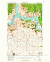
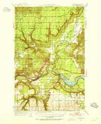
 1948 Lincoln1968 Print · USGSThe mid-century transformation of the upper Columbia River is captured here as the new reservoir rises. Researchers can trace the legacy of Fort Spokane, old schoolhouses like Enterprise Sch, and the layout of Bachelor Prairie.2 unique versions available
 - 1948 Map of Turtle Lake, 1969 Print
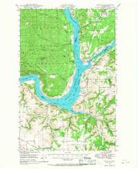
 1948 Turtle Lake1969 Print · USGSThe Spokane River and the newly formed Franklin D. Roosevelt Lake define the landscape of Stevens County in the late 1940s. Genealogists can trace family connections at Egypt Ch, the St Augustine Sch, or the Germania Consolidated Mine.
 - 1950 Map of Lincoln
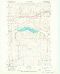
 1950 Lincoln1950 Print · USGSThe Columbia and Spokane Rivers converge here just after the filling of Lake Roosevelt, shaping the borders of two tribal nations. Genealogists and local historians can locate early schools like Rothlisburg Sch, the landmark Fort Spokane, and the community of Lincoln.2 unique versions available
 - 1950 Map of Turtle Lake
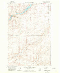
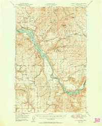 1950 Turtle Lake1950 Print · USGSThe Spokane Indian Reservation and the newly formed reservoir at Franklin D Roosevelt Lake dominate this mid-century survey. Genealogists and historians can locate the Germania Mine, the Church of Our Lady of Lourdes, and rural landmarks like Egypt Ch.2 unique versions available
 - 1950 Map of Wilbur
 1950 Wilbur1950 Print · USGSThe Washington plateau and the newly formed Franklin D Roosevelt Lake appear here in the late 1940s as the regional landscape adjusted to massive hydrological change. Genealogists can locate family landmarks in Wilbur and Creston, or trace rural life through the Potlatch Grange and Keller Ferry.
 - 1950 Map of Grand Coulee Dam
 1950 Grand Coulee Dam1950 Print · USGSThe Grand Coulee region during the late 1940s reveals a landscape transformed by the new reservoir and the massive engineering of the dam. Researchers can trace local history through the Lafollette Cem, the community at Elmer City, and rural sites like the Grand Coulee Grange.2 unique versions available
 - 1953 Map of Reardan, 1954 Print
 1953 Reardan1954 Print · USGSThe Lincoln County wheat country near the Spokane border is captured here during the early fifties as the region's rural social life thrived. Researchers can trace the rail-and-road network connecting Reardan and Edwall, finding local landmarks like the Pleasant View Cem and West Deep Creek Grange.2 unique versions available
 - 1953 Map of Wellpinit, 1955 Print
 1953 Wellpinit1955 Print · USGSThe Spokane Indian Reservation and the rugged Stevens County hills come to life in the early fifties. Genealogists and historians can locate St Joseph Ch, the Wellpinit settlement, and local landmarks like Little Chamokane Falls.3 unique versions available
 - 1953 Map of Ritzville, 1966 Print
 1953 Ritzville1966 Print · USGSEastern Washington was undergoing a massive agricultural and industrial transformation in the mid-fifties as irrigation from the Grand Coulee Dam reached the plateau. Researchers can trace the mid-century rail network of the Great Northern and locate vital local sites like Larson Air Force Base and Odessa.3 unique versions available
 - 1954 Map of Sprague, 1956 Print
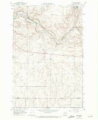
 1954 Sprague1956 Print · USGSEastern Washington’s Channeled Scablands are captured in the mid-1950s, showing a complex network of four major railroads crossing the rocky terrain. Genealogists and rail historians can trace the foundations of Sprague, the community at Fishtrap, and the Aban'd Sch near Tyler.2 unique versions available
 - 1955 Map of Spokane, 1965 Print
 1955 Spokane1965 Print · USGSInland Empire life in the fifties and sixties centers on the growth of Spokane and the heavy mining industry of northern Idaho. Trace mid-century landmarks like Fairchild Air Force Base, the Bunker Hill Mine, and early campuses such as Gonzaga University.2 unique versions available
 - 1958 Map of Spokane
 1958 Spokane1958 Print · USGSThe Inland Empire is shown at a mid-century peak of industrial and military activity, from the rail hubs of Spokane to the deep silver mines of northern Idaho. Researchers can trace the sprawling rail lines of the Union Pacific RR or locate landmarks like Fairchild Air Force Base and the Bunker Hill Smelter & Mine.
 - 1959 Map of Ritzville
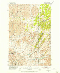
 1959 Ritzville1959 Print · USGSEastern Washington in the late fifties reveals a landscape transformed by massive irrigation projects and postwar growth. Genealogists and historians can trace rail-line communities from Ritzville to Davenport and locate landmarks like Larson Air Force Base and Telford Station.
 - 1965 Map of Ritzville
 1965 Ritzville1965 Print · USGSCentral Washington during the mid-sixties shows a landscape shaped by massive irrigation projects and the Cold War. Genealogists and historians can trace rail-town life and military presence through Ephrata Air Base, the Telford Station, and local schools.
 - 1968 Map of Marlin SW, 1971 Print
 1968 Marlin SW1971 Print · USGSEastern Washington ranch land and the Channeled Scablands are captured here in the late sixties, showing a landscape defined by water and rail. Trace the historic route of the Burlington Northern Railroad along Crab Creek or locate local landmarks like Black Rock Coulee.2 unique versions available
 - 1968 Map of Irby, 1971 Print
 1968 Irby1971 Print · USGSLincoln County in the late 1960s shows a landscape of railroads and remote settlements along the Crab Creek valley. Trace the old Burlington Northern line through Irby and find rural landmarks like Bungalow and Bobs Lakes.
 - 1968 Map of Sylvan Lake, 1971 Print
 1968 Sylvan Lake1971 Print · USGSThe Lincoln and Adams county line comes into focus in the late 1960s, showing a quiet landscape of water gaps and rail lines. Genealogists and historians can trace the paths of Davis Road and Nielson Road near the settlement of Nemo.
 - 1968 Map of Coffeepot Lake, 1971 Print
 1968 Coffeepot Lake1971 Print · USGSLincoln County in the late 1960s remains a landscape of open coulees and basalt outcrops centered around the waters of Coffeepot Lake. Researchers can trace the reach of rural infrastructure through the presence of Storage Bins, a long Pipeline, and remote Gravel Pits.
 - 1968 Map of Marlin, 1971 Print
 1968 Marlin1971 Print · USGSMarlin and the surrounding Big Bend country are captured in the late sixties as the rail-and-river economy shaped this high desert landscape. Genealogists and local historians can locate Zion Church, the local Cem, and trace the Burlington Northern line along Crab Creek.2 unique versions available
 - 1968 Map of Pacific Lake, 1971 Print
 1968 Pacific Lake1971 Print · USGSLincoln County at the end of the sixties reveals a landscape of interconnected water bodies and family-named landmarks. Researchers can trace land use through features like Allington Bay, a small rural Cem, and the various family holdings at Woderspahn Lake.
 - 1968 Map of Odessa, 1971 Print
 1968 Odessa1971 Print · USGSOdessa thrived as a rail and ranching hub in the late sixties, where the scabland coulees meet the valley floor. Genealogists and researchers can trace family landmarks like the Reich Windmill and Adams, or locate the Odessa Cem.
Showing maps 1-25 of 364
Top cities of Lincoln County
- Davenport historical maps
- Odessa historical maps
- Wilbur historical maps
- Reardan historical maps
- Sprague historical maps
- Harrington historical maps
See more
Frequently asked questions
- What are the different types of historical maps available for Lincoln County?
- What is the oldest map of Lincoln County?
- Where can I purchase historical maps of Lincoln County for my home or office?
- Where can I download high-res historical maps of Lincoln County?
- Are there historical topographic maps available for Lincoln County?
- Is there historical aerial imagery available for Lincoln County?
- Where are historical maps of Lincoln County sourced from?